You are here: Home > Network List > TA - USArray Transportable Network (new EarthScope stations) Stations List
> Station J37A Redenius Farm, Forest, IA, USA > Earthquake Result Viewer
J37A Redenius Farm, Forest, IA, USA - Earthquake Result Viewer

| Earthquake location: |
Near Coast Of Central Chile |
| Earthquake latitude/longitude: |
-38.4/-73.3 |
| Earthquake time(UTC): |
2011/01/02 (002) 20:20:17 GMT |
| Earthquake Depth: |
24 km |
| Earthquake Magnitude: |
6.6 MB, 7.1 MS, 7.1 MW, 7.0 MW |
| Earthquake Catalog/Contributor: |
WHDF/NEIC |
|
| Network: |
TA USArray Transportable Network (new EarthScope stations) |
| Station: |
J37A Redenius Farm, Forest, IA, USA |
| Lat/Lon: |
43.31 N/93.55 W |
| Elevation: |
385 m |
|
| Distance: |
83.3 deg |
| Az: |
345.281 deg |
| Baz: |
164.117 deg |
| Ray Param: |
0.046237636 |
| Estimated Moho Depth: |
48.25 km |
| Estimated Crust Vp/Vs: |
1.67 |
| Assumed Crust Vp: |
6.53 km/s |
| Estimated Crust Vs: |
3.91 km/s |
| Estimated Crust Poisson's Ratio: |
0.22 |
|
| Radial Match: |
91.25756 % |
| Radial Bump: |
293 |
| Transverse Match: |
87.40606 % |
| Transverse Bump: |
392 |
| SOD ConfigId: |
346946 |
| Insert Time: |
2011-07-04 10:28:19.559 +0000 |
| GWidth: |
2.5 |
| Max Bumps: |
400 |
| Tol: |
0.001 |
|
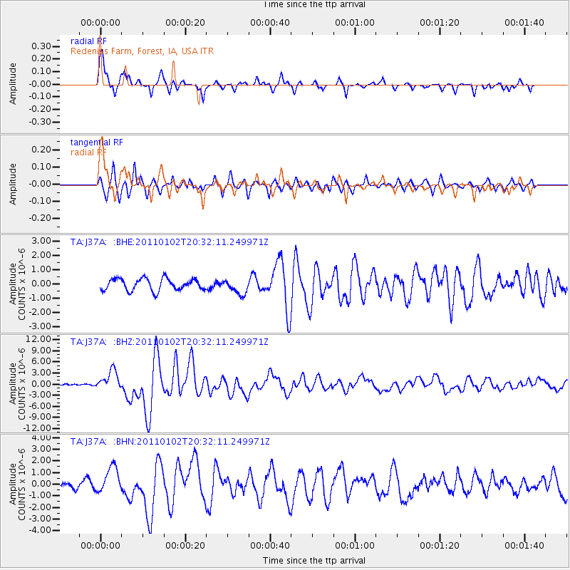
Signal To Noise
| Channel | StoN | STA | LTA |
| TA:J37A: :BHZ:20110102T20:32:11.249971Z | 10.59951 | 2.7125125E-6 | 2.5590924E-7 |
| TA:J37A: :BHN:20110102T20:32:11.249971Z | 2.6780553 | 1.1575307E-6 | 4.3222806E-7 |
| TA:J37A: :BHE:20110102T20:32:11.249971Z | 1.304958 | 5.363845E-7 | 4.110358E-7 |
| Arrivals |
| Ps | 5.1 SECOND |
| PpPs | 19 SECOND |
| PsPs/PpSs | 24 SECOND |


