You are here: Home > Network List > TA - USArray Transportable Network (new EarthScope stations) Stations List
> Station G33A Ortonville, MN, USA > Earthquake Result Viewer
G33A Ortonville, MN, USA - Earthquake Result Viewer

| Earthquake location: |
Near Coast Of Central Chile |
| Earthquake latitude/longitude: |
-38.4/-73.3 |
| Earthquake time(UTC): |
2011/01/02 (002) 20:20:17 GMT |
| Earthquake Depth: |
24 km |
| Earthquake Magnitude: |
6.6 MB, 7.1 MS, 7.1 MW, 7.0 MW |
| Earthquake Catalog/Contributor: |
WHDF/NEIC |
|
| Network: |
TA USArray Transportable Network (new EarthScope stations) |
| Station: |
G33A Ortonville, MN, USA |
| Lat/Lon: |
45.19 N/96.44 W |
| Elevation: |
338 m |
|
| Distance: |
85.7 deg |
| Az: |
343.84 deg |
| Baz: |
161.973 deg |
| Ray Param: |
0.044523478 |
| Estimated Moho Depth: |
37.0 km |
| Estimated Crust Vp/Vs: |
1.63 |
| Assumed Crust Vp: |
6.552 km/s |
| Estimated Crust Vs: |
4.008 km/s |
| Estimated Crust Poisson's Ratio: |
0.20 |
|
| Radial Match: |
95.65173 % |
| Radial Bump: |
395 |
| Transverse Match: |
89.11048 % |
| Transverse Bump: |
388 |
| SOD ConfigId: |
346946 |
| Insert Time: |
2011-07-04 10:28:44.387 +0000 |
| GWidth: |
2.5 |
| Max Bumps: |
400 |
| Tol: |
0.001 |
|
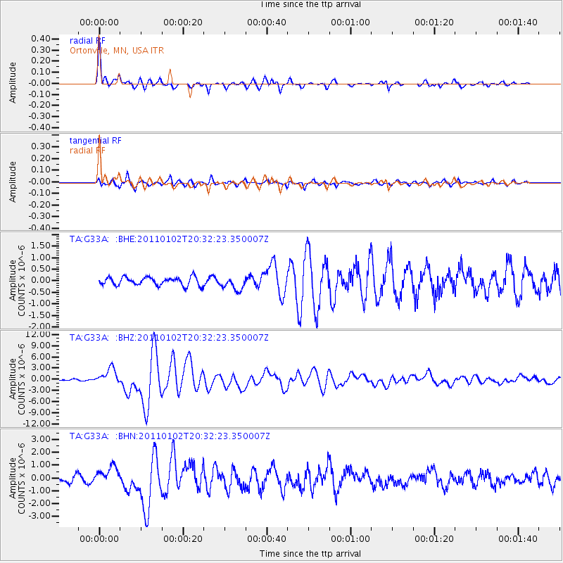
Signal To Noise
| Channel | StoN | STA | LTA |
| TA:G33A: :BHZ:20110102T20:32:23.350007Z | 18.062391 | 2.1748326E-6 | 1.2040668E-7 |
| TA:G33A: :BHN:20110102T20:32:23.350007Z | 4.13184 | 7.0910784E-7 | 1.7162034E-7 |
| TA:G33A: :BHE:20110102T20:32:23.350007Z | 1.6598074 | 2.9196448E-7 | 1.7590261E-7 |
| Arrivals |
| Ps | 3.7 SECOND |
| PpPs | 14 SECOND |
| PsPs/PpSs | 18 SECOND |


