You are here: Home > Network List > TA - USArray Transportable Network (new EarthScope stations) Stations List
> Station J38A Wedel Dairy, Riceville, IA, USA > Earthquake Result Viewer
J38A Wedel Dairy, Riceville, IA, USA - Earthquake Result Viewer
| Earthquake location: |
Near Coast Of Central Chile |
| Earthquake latitude/longitude: |
-38.4/-73.3 |
| Earthquake time(UTC): |
2011/01/02 (002) 20:20:17 GMT |
| Earthquake Depth: |
24 km |
| Earthquake Magnitude: |
6.6 MB, 7.1 MS, 7.1 MW, 7.0 MW |
| Earthquake Catalog/Contributor: |
WHDF/NEIC |
|
| Network: |
TA USArray Transportable Network (new EarthScope stations) |
| Station: |
J38A Wedel Dairy, Riceville, IA, USA |
| Lat/Lon: |
43.32 N/92.48 W |
| Elevation: |
371 m |
|
| Distance: |
83.1 deg |
| Az: |
346.046 deg |
| Baz: |
164.944 deg |
| Ray Param: |
0.046380173 |
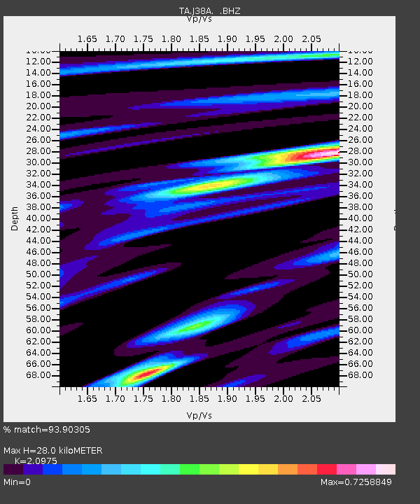
| Estimated Moho Depth: |
28.0 km |
| Estimated Crust Vp/Vs: |
2.10 |
| Assumed Crust Vp: |
6.53 km/s |
| Estimated Crust Vs: |
3.113 km/s |
| Estimated Crust Poisson's Ratio: |
0.35 |
|
| Radial Match: |
93.90305 % |
| Radial Bump: |
274 |
| Transverse Match: |
84.61875 % |
| Transverse Bump: |
400 |
| SOD ConfigId: |
346946 |
| Insert Time: |
2011-07-04 10:29:54.525 +0000 |
| GWidth: |
2.5 |
| Max Bumps: |
400 |
| Tol: |
0.001 |
|
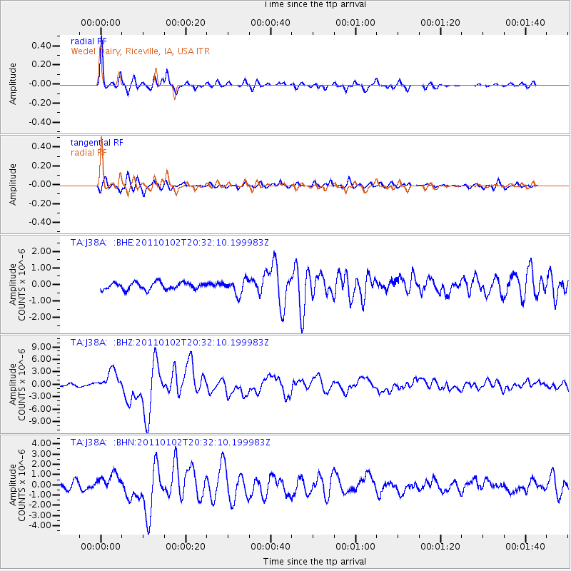
Signal To Noise
| Channel | StoN | STA | LTA |
| TA:J38A: :BHZ:20110102T20:32:10.199983Z | 10.452038 | 2.4656586E-6 | 2.3590218E-7 |
| TA:J38A: :BHN:20110102T20:32:10.199983Z | 2.2422354 | 8.483706E-7 | 3.7835926E-7 |
| TA:J38A: :BHE:20110102T20:32:10.199983Z | 2.1421168 | 4.4676335E-7 | 2.0856162E-7 |
| Arrivals |
| Ps | 4.8 SECOND |
| PpPs | 13 SECOND |
| PsPs/PpSs | 18 SECOND |


