You are here: Home > Network List > TA - USArray Transportable Network (new EarthScope stations) Stations List
> Station B33A Robert and Kassanda Mosher, Grygla, MN, USA > Earthquake Result Viewer
B33A Robert and Kassanda Mosher, Grygla, MN, USA - Earthquake Result Viewer
| Earthquake location: |
Near Coast Of Central Chile |
| Earthquake latitude/longitude: |
-38.4/-73.3 |
| Earthquake time(UTC): |
2011/01/02 (002) 20:20:17 GMT |
| Earthquake Depth: |
24 km |
| Earthquake Magnitude: |
6.6 MB, 7.1 MS, 7.1 MW, 7.0 MW |
| Earthquake Catalog/Contributor: |
WHDF/NEIC |
|
| Network: |
TA USArray Transportable Network (new EarthScope stations) |
| Station: |
B33A Robert and Kassanda Mosher, Grygla, MN, USA |
| Lat/Lon: |
48.27 N/95.59 W |
| Elevation: |
362 m |
|
| Distance: |
88.5 deg |
| Az: |
345.334 deg |
| Baz: |
162.665 deg |
| Ray Param: |
0.042519733 |
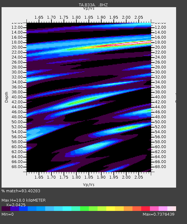
| Estimated Moho Depth: |
18.0 km |
| Estimated Crust Vp/Vs: |
2.04 |
| Assumed Crust Vp: |
6.419 km/s |
| Estimated Crust Vs: |
3.143 km/s |
| Estimated Crust Poisson's Ratio: |
0.34 |
|
| Radial Match: |
93.40283 % |
| Radial Bump: |
264 |
| Transverse Match: |
85.37671 % |
| Transverse Bump: |
400 |
| SOD ConfigId: |
346946 |
| Insert Time: |
2011-07-04 10:32:45.549 +0000 |
| GWidth: |
2.5 |
| Max Bumps: |
400 |
| Tol: |
0.001 |
|

Signal To Noise
| Channel | StoN | STA | LTA |
| TA:B33A: :BHZ:20110102T20:32:36.67502Z | 6.765516 | 2.1731773E-6 | 3.2121383E-7 |
| TA:B33A: :BHN:20110102T20:32:36.67502Z | 2.243268 | 6.7786976E-7 | 3.0217956E-7 |
| TA:B33A: :BHE:20110102T20:32:36.67502Z | 1.3872167 | 3.1313658E-7 | 2.2573012E-7 |
| Arrivals |
| Ps | 3.0 SECOND |
| PpPs | 8.4 SECOND |
| PsPs/PpSs | 11 SECOND |


