You are here: Home > Network List > TA - USArray Transportable Network (new EarthScope stations) Stations List
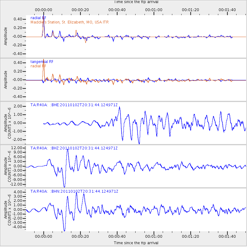
> Station R40A Maddie's Station, St. Elizabeth, MO, USA > Earthquake Result Viewer
R40A Maddie's Station, St. Elizabeth, MO, USA - Earthquake Result Viewer
| Earthquake location: |
Near Coast Of Central Chile |
| Earthquake latitude/longitude: |
-38.4/-73.3 |
| Earthquake time(UTC): |
2011/01/02 (002) 20:20:17 GMT |
| Earthquake Depth: |
24 km |
| Earthquake Magnitude: |
6.6 MB, 7.1 MS, 7.1 MW, 7.0 MW |
| Earthquake Catalog/Contributor: |
WHDF/NEIC |
|
| Network: |
TA USArray Transportable Network (new EarthScope stations) |
| Station: |
R40A Maddie's Station, St. Elizabeth, MO, USA |
| Lat/Lon: |
38.29 N/92.27 W |
| Elevation: |
213 m |
|
| Distance: |
78.2 deg |
| Az: |
344.876 deg |
| Baz: |
164.889 deg |
| Ray Param: |
0.049749445 |
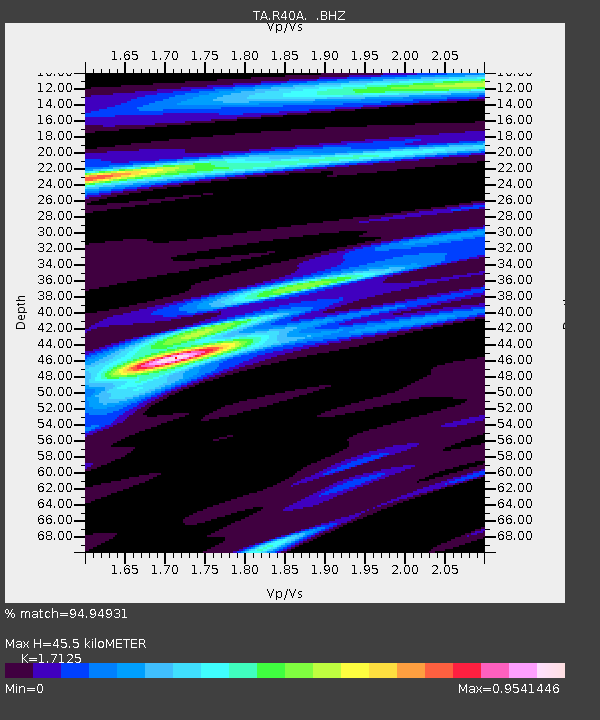
| Estimated Moho Depth: |
45.5 km |
| Estimated Crust Vp/Vs: |
1.71 |
| Assumed Crust Vp: |
6.498 km/s |
| Estimated Crust Vs: |
3.794 km/s |
| Estimated Crust Poisson's Ratio: |
0.24 |
|
| Radial Match: |
94.94931 % |
| Radial Bump: |
268 |
| Transverse Match: |
89.79783 % |
| Transverse Bump: |
400 |
| SOD ConfigId: |
346946 |
| Insert Time: |
2011-07-04 10:45:02.703 +0000 |
| GWidth: |
2.5 |
| Max Bumps: |
400 |
| Tol: |
0.001 |
|
Signal To Noise
| Channel | StoN | STA | LTA |
| TA:R40A: :BHZ:20110102T20:31:44.124971Z | 10.845276 | 2.4651843E-6 | 2.273049E-7 |
| TA:R40A: :BHN:20110102T20:31:44.124971Z | 3.7254686 | 8.9506665E-7 | 2.402561E-7 |
| TA:R40A: :BHE:20110102T20:31:44.124971Z | 2.1252317 | 2.5662695E-7 | 1.2075246E-7 |
| Arrivals |
| Ps | 5.1 SECOND |
| PpPs | 18 SECOND |
| PsPs/PpSs | 24 SECOND |


