You are here: Home > Network List > US - United States National Seismic Network Stations List
> Station MIAR Mount Ida, Arkansas, USA > Earthquake Result Viewer
MIAR Mount Ida, Arkansas, USA - Earthquake Result Viewer
| Earthquake location: |
Near Coast Of Central Chile |
| Earthquake latitude/longitude: |
-38.4/-73.3 |
| Earthquake time(UTC): |
2011/01/02 (002) 20:20:17 GMT |
| Earthquake Depth: |
24 km |
| Earthquake Magnitude: |
6.6 MB, 7.1 MS, 7.1 MW, 7.0 MW |
| Earthquake Catalog/Contributor: |
WHDF/NEIC |
|
| Network: |
US United States National Seismic Network |
| Station: |
MIAR Mount Ida, Arkansas, USA |
| Lat/Lon: |
34.55 N/93.58 W |
| Elevation: |
207 m |
|
| Distance: |
74.9 deg |
| Az: |
342.789 deg |
| Baz: |
163.631 deg |
| Ray Param: |
0.05197645 |
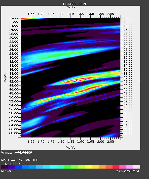
| Estimated Moho Depth: |
41.25 km |
| Estimated Crust Vp/Vs: |
1.88 |
| Assumed Crust Vp: |
6.498 km/s |
| Estimated Crust Vs: |
3.461 km/s |
| Estimated Crust Poisson's Ratio: |
0.30 |
|
| Radial Match: |
96.96609 % |
| Radial Bump: |
382 |
| Transverse Match: |
88.99713 % |
| Transverse Bump: |
400 |
| SOD ConfigId: |
346946 |
| Insert Time: |
2011-07-04 10:46:48.339 +0000 |
| GWidth: |
2.5 |
| Max Bumps: |
400 |
| Tol: |
0.001 |
|

Signal To Noise
| Channel | StoN | STA | LTA |
| US:MIAR: :BHZ:20110102T20:31:25.449983Z | 9.335486 | 2.1909314E-6 | 2.346885E-7 |
| US:MIAR: :BHN:20110102T20:31:25.449983Z | 7.641607 | 8.613677E-7 | 1.12720755E-7 |
| US:MIAR: :BHE:20110102T20:31:25.449983Z | 2.2322366 | 2.5723764E-7 | 1.1523762E-7 |
| Arrivals |
| Ps | 5.7 SECOND |
| PpPs | 18 SECOND |
| PsPs/PpSs | 23 SECOND |


