You are here: Home > Network List > US - United States National Seismic Network Stations List
> Station OGNE Ogallala, Nebraska, USA > Earthquake Result Viewer
OGNE Ogallala, Nebraska, USA - Earthquake Result Viewer
| Earthquake location: |
Near Coast Of Central Chile |
| Earthquake latitude/longitude: |
-38.4/-73.3 |
| Earthquake time(UTC): |
2011/01/02 (002) 20:20:17 GMT |
| Earthquake Depth: |
24 km |
| Earthquake Magnitude: |
6.6 MB, 7.1 MS, 7.1 MW, 7.0 MW |
| Earthquake Catalog/Contributor: |
WHDF/NEIC |
|
| Network: |
US United States National Seismic Network |
| Station: |
OGNE Ogallala, Nebraska, USA |
| Lat/Lon: |
40.95 N/102.03 W |
| Elevation: |
0.0 m |
|
| Distance: |
83.2 deg |
| Az: |
338.503 deg |
| Baz: |
157.645 deg |
| Ray Param: |
0.0463535 |
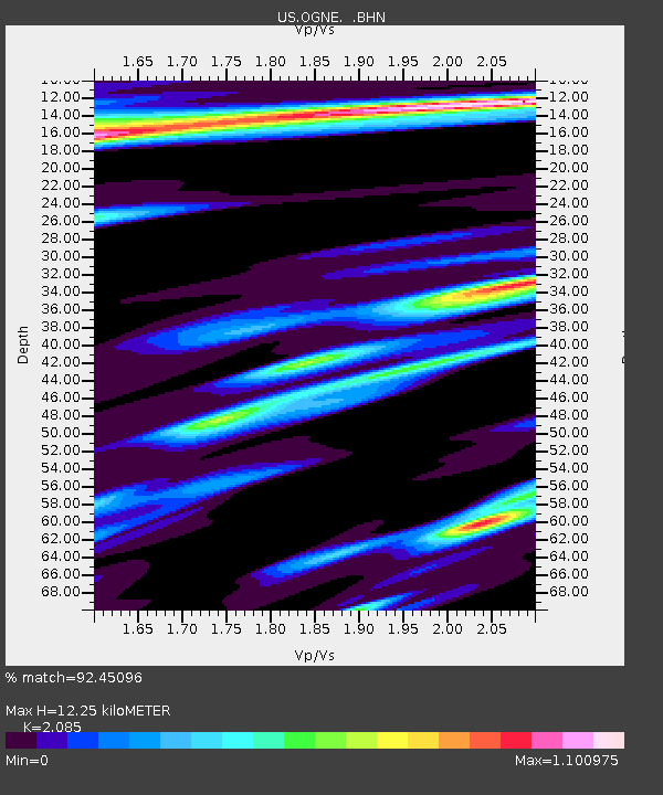
| Estimated Moho Depth: |
12.25 km |
| Estimated Crust Vp/Vs: |
2.09 |
| Assumed Crust Vp: |
6.483 km/s |
| Estimated Crust Vs: |
3.109 km/s |
| Estimated Crust Poisson's Ratio: |
0.35 |
|
| Radial Match: |
92.45096 % |
| Radial Bump: |
255 |
| Transverse Match: |
91.58621 % |
| Transverse Bump: |
316 |
| SOD ConfigId: |
346946 |
| Insert Time: |
2011-07-04 11:09:01.833 +0000 |
| GWidth: |
2.5 |
| Max Bumps: |
400 |
| Tol: |
0.001 |
|
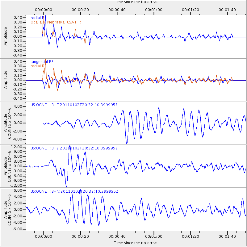
Signal To Noise
| Channel | StoN | STA | LTA |
| US:OGNE: :BHZ:20110102T20:32:10.399995Z | 8.610698 | 2.0755954E-6 | 2.4104847E-7 |
| US:OGNE: :BHN:20110102T20:32:10.399995Z | 1.1535342 | 7.0349495E-7 | 6.0986054E-7 |
| US:OGNE: :BHE:20110102T20:32:10.399995Z | 0.9304785 | 4.88015E-7 | 5.2447746E-7 |
| Arrivals |
| Ps | 2.1 SECOND |
| PpPs | 5.7 SECOND |
| PsPs/PpSs | 7.8 SECOND |


