You are here: Home > Network List > XG92 - Rocky Mountain Front Stations List
> Station KRM Kremlin, CO > Earthquake Result Viewer
KRM Kremlin, CO - Earthquake Result Viewer
| Earthquake location: |
Andreanof Islands, Aleutian Is. |
| Earthquake latitude/longitude: |
50.5/-174.8 |
| Earthquake time(UTC): |
1992/08/19 (232) 00:57:43 GMT |
| Earthquake Depth: |
33 km |
| Earthquake Magnitude: |
6.1 MB, 5.7 MS, 5.6 ML |
| Earthquake Catalog/Contributor: |
WHDF/NEIC |
|
| Network: |
XG Rocky Mountain Front |
| Station: |
KRM Kremlin, CO |
| Lat/Lon: |
40.13 N/106.40 W |
| Elevation: |
2458 m |
|
| Distance: |
47.6 deg |
| Az: |
74.823 deg |
| Baz: |
306.464 deg |
| Ray Param: |
0.06980186 |
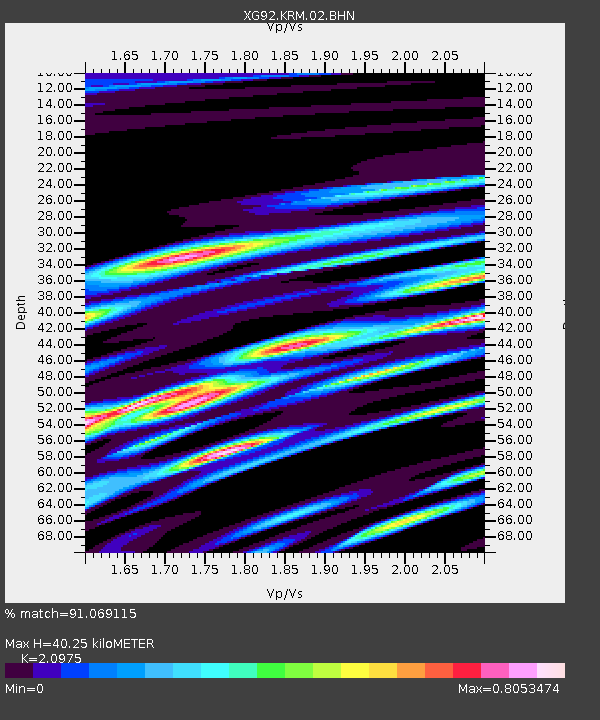
| Estimated Moho Depth: |
40.25 km |
| Estimated Crust Vp/Vs: |
2.10 |
| Assumed Crust Vp: |
6.159 km/s |
| Estimated Crust Vs: |
2.936 km/s |
| Estimated Crust Poisson's Ratio: |
0.35 |
|
| Radial Match: |
91.069115 % |
| Radial Bump: |
400 |
| Transverse Match: |
72.00422 % |
| Transverse Bump: |
400 |
| SOD ConfigId: |
3286 |
| Insert Time: |
2010-02-25 20:09:35.083 +0000 |
| GWidth: |
2.5 |
| Max Bumps: |
400 |
| Tol: |
0.001 |
|

Signal To Noise
| Channel | StoN | STA | LTA |
| XG:KRM:02:BHN:19920819T01:05:45.963007Z | 1.8054898 | 5.9036098E-5 | 3.2698106E-5 |
| XG:KRM:02:BHE:19920819T01:05:45.963007Z | 2.4947927 | 8.471634E-5 | 3.3957265E-5 |
| XG:KRM:02:BHZ:19920819T01:05:45.963007Z | 6.278217 | 2.3655362E-4 | 3.7678474E-5 |
| Arrivals |
| Ps | 7.5 SECOND |
| PpPs | 19 SECOND |
| PsPs/PpSs | 27 SECOND |


