You are here: Home > Network List > TA - USArray Transportable Network (new EarthScope stations) Stations List
> Station R30A Dighton, KS, USA > Earthquake Result Viewer
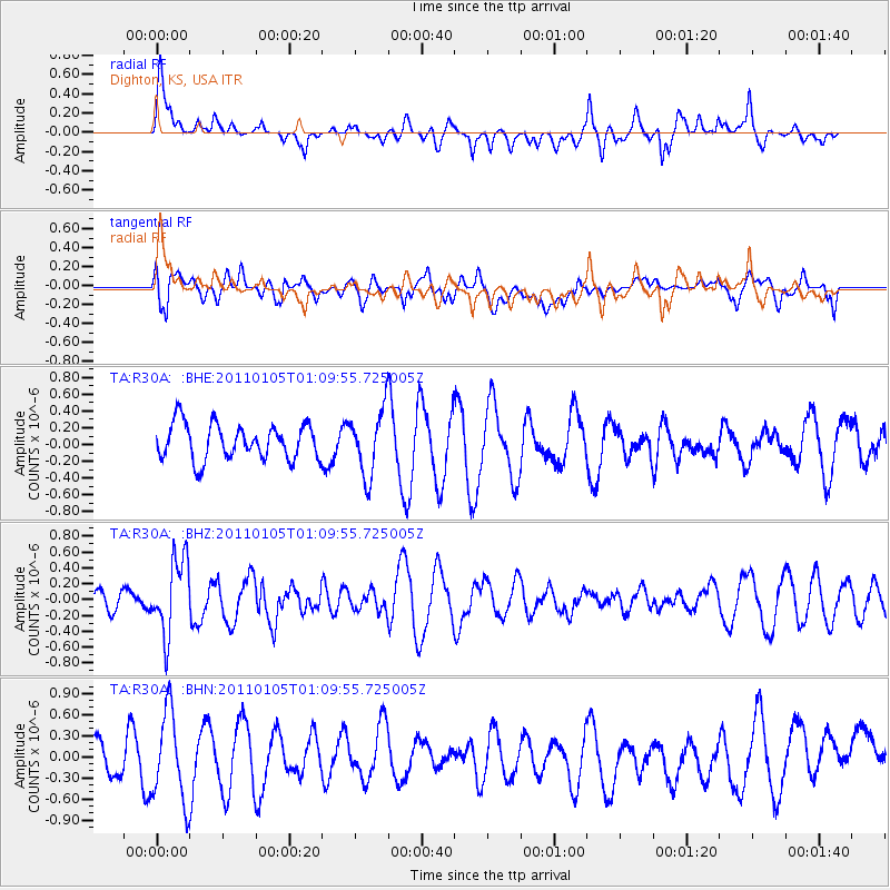
R30A Dighton, KS, USA - Earthquake Result Viewer
*The percent match for this event was below the threshold and hence no stack was calculated.
| Earthquake location: |
Southeast Of Honshu, Japan |
| Earthquake latitude/longitude: |
31.5/142.2 |
| Earthquake time(UTC): |
2011/01/05 (005) 00:57:32 GMT |
| Earthquake Depth: |
21 km |
| Earthquake Magnitude: |
6.0 MB, 5.4 MS, 5.6 MW |
| Earthquake Catalog/Contributor: |
WHDF/NEIC |
|
| Network: |
TA USArray Transportable Network (new EarthScope stations) |
| Station: |
R30A Dighton, KS, USA |
| Lat/Lon: |
38.28 N/100.28 W |
| Elevation: |
776 m |
|
| Distance: |
89.4 deg |
| Az: |
44.25 deg |
| Baz: |
310.796 deg |
| Ray Param: |
$rayparam |
*The percent match for this event was below the threshold and hence was not used in the summary stack. |
|
| Radial Match: |
31.643433 % |
| Radial Bump: |
400 |
| Transverse Match: |
51.227234 % |
| Transverse Bump: |
400 |
| SOD ConfigId: |
346946 |
| Insert Time: |
2011-07-04 12:28:01.899 +0000 |
| GWidth: |
2.5 |
| Max Bumps: |
400 |
| Tol: |
0.001 |
|
Signal To Noise
| Channel | StoN | STA | LTA |
| TA:R30A: :BHZ:20110105T01:09:55.725005Z | 3.154572 | 4.7643587E-7 | 1.5103028E-7 |
| TA:R30A: :BHN:20110105T01:09:55.725005Z | 2.2375662 | 6.4766743E-7 | 2.8945172E-7 |
| TA:R30A: :BHE:20110105T01:09:55.725005Z | 1.823148 | 3.8313968E-7 | 2.101528E-7 |
| Arrivals |
| Ps | |
| PpPs | |
| PsPs/PpSs | |


