You are here: Home > Network List > TA - USArray Transportable Network (new EarthScope stations) Stations List
> Station R29A Marienthal, KS, USA > Earthquake Result Viewer
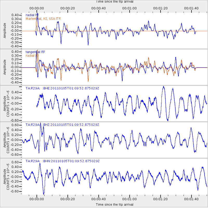
R29A Marienthal, KS, USA - Earthquake Result Viewer
*The percent match for this event was below the threshold and hence no stack was calculated.
| Earthquake location: |
Southeast Of Honshu, Japan |
| Earthquake latitude/longitude: |
31.5/142.2 |
| Earthquake time(UTC): |
2011/01/05 (005) 00:57:32 GMT |
| Earthquake Depth: |
21 km |
| Earthquake Magnitude: |
6.0 MB, 5.4 MS, 5.6 MW |
| Earthquake Catalog/Contributor: |
WHDF/NEIC |
|
| Network: |
TA USArray Transportable Network (new EarthScope stations) |
| Station: |
R29A Marienthal, KS, USA |
| Lat/Lon: |
38.42 N/101.14 W |
| Elevation: |
957 m |
|
| Distance: |
88.8 deg |
| Az: |
44.584 deg |
| Baz: |
310.269 deg |
| Ray Param: |
$rayparam |
*The percent match for this event was below the threshold and hence was not used in the summary stack. |
|
| Radial Match: |
66.72062 % |
| Radial Bump: |
400 |
| Transverse Match: |
55.67795 % |
| Transverse Bump: |
400 |
| SOD ConfigId: |
346946 |
| Insert Time: |
2011-07-04 12:28:18.401 +0000 |
| GWidth: |
2.5 |
| Max Bumps: |
400 |
| Tol: |
0.001 |
|
Signal To Noise
| Channel | StoN | STA | LTA |
| TA:R29A: :BHZ:20110105T01:09:52.875029Z | 2.3906026 | 3.576541E-7 | 1.4960834E-7 |
| TA:R29A: :BHN:20110105T01:09:52.875029Z | 2.22471 | 3.4760086E-7 | 1.5624546E-7 |
| TA:R29A: :BHE:20110105T01:09:52.875029Z | 0.86475974 | 1.5083442E-7 | 1.744235E-7 |
| Arrivals |
| Ps | |
| PpPs | |
| PsPs/PpSs | |


