You are here: Home > Network List > TA - USArray Transportable Network (new EarthScope stations) Stations List
> Station I27A Quinn, SD, USA > Earthquake Result Viewer
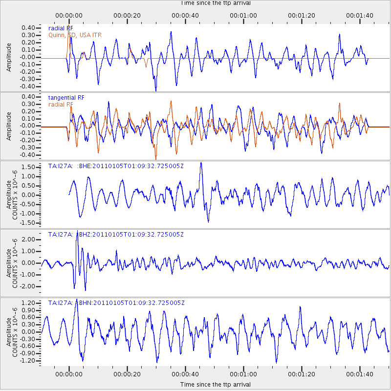
I27A Quinn, SD, USA - Earthquake Result Viewer
*The percent match for this event was below the threshold and hence no stack was calculated.
| Earthquake location: |
Southeast Of Honshu, Japan |
| Earthquake latitude/longitude: |
31.5/142.2 |
| Earthquake time(UTC): |
2011/01/05 (005) 00:57:32 GMT |
| Earthquake Depth: |
21 km |
| Earthquake Magnitude: |
6.0 MB, 5.4 MS, 5.6 MW |
| Earthquake Catalog/Contributor: |
WHDF/NEIC |
|
| Network: |
TA USArray Transportable Network (new EarthScope stations) |
| Station: |
I27A Quinn, SD, USA |
| Lat/Lon: |
44.07 N/102.05 W |
| Elevation: |
867 m |
|
| Distance: |
84.6 deg |
| Az: |
40.691 deg |
| Baz: |
309.444 deg |
| Ray Param: |
$rayparam |
*The percent match for this event was below the threshold and hence was not used in the summary stack. |
|
| Radial Match: |
52.58991 % |
| Radial Bump: |
375 |
| Transverse Match: |
63.4978 % |
| Transverse Bump: |
400 |
| SOD ConfigId: |
346946 |
| Insert Time: |
2011-07-04 12:35:28.485 +0000 |
| GWidth: |
2.5 |
| Max Bumps: |
400 |
| Tol: |
0.001 |
|
Signal To Noise
| Channel | StoN | STA | LTA |
| TA:I27A: :BHZ:20110105T01:09:32.725005Z | 4.260749 | 1.1400838E-6 | 2.6757826E-7 |
| TA:I27A: :BHN:20110105T01:09:32.725005Z | 2.614679 | 7.4521625E-7 | 2.8501253E-7 |
| TA:I27A: :BHE:20110105T01:09:32.725005Z | 0.59173316 | 2.9831227E-7 | 5.041331E-7 |
| Arrivals |
| Ps | |
| PpPs | |
| PsPs/PpSs | |


