You are here: Home > Network List > TA - USArray Transportable Network (new EarthScope stations) Stations List
> Station D28A Regan, ND, USA > Earthquake Result Viewer
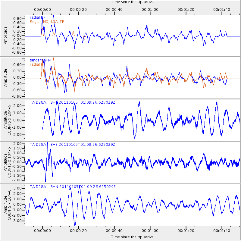
D28A Regan, ND, USA - Earthquake Result Viewer
*The percent match for this event was below the threshold and hence no stack was calculated.
| Earthquake location: |
Southeast Of Honshu, Japan |
| Earthquake latitude/longitude: |
31.5/142.2 |
| Earthquake time(UTC): |
2011/01/05 (005) 00:57:32 GMT |
| Earthquake Depth: |
21 km |
| Earthquake Magnitude: |
6.0 MB, 5.4 MS, 5.6 MW |
| Earthquake Catalog/Contributor: |
WHDF/NEIC |
|
| Network: |
TA USArray Transportable Network (new EarthScope stations) |
| Station: |
D28A Regan, ND, USA |
| Lat/Lon: |
47.19 N/100.57 W |
| Elevation: |
621 m |
|
| Distance: |
83.4 deg |
| Az: |
37.609 deg |
| Baz: |
310.182 deg |
| Ray Param: |
$rayparam |
*The percent match for this event was below the threshold and hence was not used in the summary stack. |
|
| Radial Match: |
48.8145 % |
| Radial Bump: |
322 |
| Transverse Match: |
57.714115 % |
| Transverse Bump: |
287 |
| SOD ConfigId: |
346946 |
| Insert Time: |
2011-07-04 12:39:48.872 +0000 |
| GWidth: |
2.5 |
| Max Bumps: |
400 |
| Tol: |
0.001 |
|
Signal To Noise
| Channel | StoN | STA | LTA |
| TA:D28A: :BHZ:20110105T01:09:26.625029Z | 3.102237 | 9.594772E-7 | 3.092856E-7 |
| TA:D28A: :BHN:20110105T01:09:26.625029Z | 0.9848236 | 7.907173E-7 | 8.029025E-7 |
| TA:D28A: :BHE:20110105T01:09:26.625029Z | 0.46694827 | 5.864446E-7 | 1.2559092E-6 |
| Arrivals |
| Ps | |
| PpPs | |
| PsPs/PpSs | |


