You are here: Home > Network List > TA - USArray Transportable Network (new EarthScope stations) Stations List
> Station E29A Napoleon, ND, USA > Earthquake Result Viewer
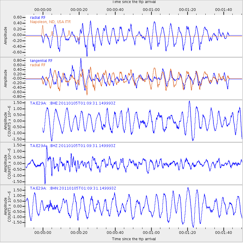
E29A Napoleon, ND, USA - Earthquake Result Viewer
*The percent match for this event was below the threshold and hence no stack was calculated.
| Earthquake location: |
Southeast Of Honshu, Japan |
| Earthquake latitude/longitude: |
31.5/142.2 |
| Earthquake time(UTC): |
2011/01/05 (005) 00:57:32 GMT |
| Earthquake Depth: |
21 km |
| Earthquake Magnitude: |
6.0 MB, 5.4 MS, 5.6 MW |
| Earthquake Catalog/Contributor: |
WHDF/NEIC |
|
| Network: |
TA USArray Transportable Network (new EarthScope stations) |
| Station: |
E29A Napoleon, ND, USA |
| Lat/Lon: |
46.57 N/99.64 W |
| Elevation: |
628 m |
|
| Distance: |
84.3 deg |
| Az: |
37.671 deg |
| Baz: |
310.863 deg |
| Ray Param: |
$rayparam |
*The percent match for this event was below the threshold and hence was not used in the summary stack. |
|
| Radial Match: |
53.982006 % |
| Radial Bump: |
400 |
| Transverse Match: |
61.449245 % |
| Transverse Bump: |
345 |
| SOD ConfigId: |
346946 |
| Insert Time: |
2011-07-04 12:42:44.165 +0000 |
| GWidth: |
2.5 |
| Max Bumps: |
400 |
| Tol: |
0.001 |
|
Signal To Noise
| Channel | StoN | STA | LTA |
| TA:E29A: :BHZ:20110105T01:09:31.149993Z | 2.7192218 | 6.818644E-7 | 2.5075718E-7 |
| TA:E29A: :BHN:20110105T01:09:31.149993Z | 0.39904672 | 3.1451918E-7 | 7.881763E-7 |
| TA:E29A: :BHE:20110105T01:09:31.149993Z | 0.62538916 | 4.2562985E-7 | 6.8058404E-7 |
| Arrivals |
| Ps | |
| PpPs | |
| PsPs/PpSs | |


