You are here: Home > Network List > TA - USArray Transportable Network (new EarthScope stations) Stations List
> Station G03D McMinnville, OR, USA > Earthquake Result Viewer
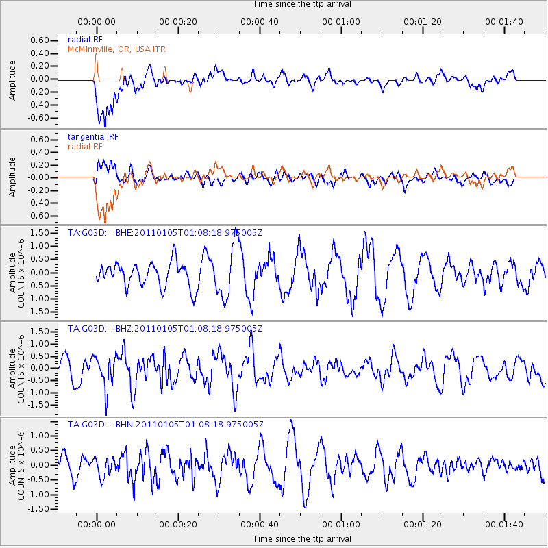
G03D McMinnville, OR, USA - Earthquake Result Viewer
*The percent match for this event was below the threshold and hence no stack was calculated.
| Earthquake location: |
Southeast Of Honshu, Japan |
| Earthquake latitude/longitude: |
31.5/142.2 |
| Earthquake time(UTC): |
2011/01/05 (005) 00:57:32 GMT |
| Earthquake Depth: |
21 km |
| Earthquake Magnitude: |
6.0 MB, 5.4 MS, 5.6 MW |
| Earthquake Catalog/Contributor: |
WHDF/NEIC |
|
| Network: |
TA USArray Transportable Network (new EarthScope stations) |
| Station: |
G03D McMinnville, OR, USA |
| Lat/Lon: |
45.21 N/123.26 W |
| Elevation: |
222 m |
|
| Distance: |
71.3 deg |
| Az: |
48.058 deg |
| Baz: |
296.049 deg |
| Ray Param: |
$rayparam |
*The percent match for this event was below the threshold and hence was not used in the summary stack. |
|
| Radial Match: |
77.93808 % |
| Radial Bump: |
400 |
| Transverse Match: |
40.8857 % |
| Transverse Bump: |
400 |
| SOD ConfigId: |
346946 |
| Insert Time: |
2011-07-04 12:49:26.883 +0000 |
| GWidth: |
2.5 |
| Max Bumps: |
400 |
| Tol: |
0.001 |
|
Signal To Noise
| Channel | StoN | STA | LTA |
| TA:G03D: :BHZ:20110105T01:08:18.975005Z | 1.8255727 | 6.4820114E-7 | 3.5506724E-7 |
| TA:G03D: :BHN:20110105T01:08:18.975005Z | 0.71421397 | 3.0842494E-7 | 4.3183832E-7 |
| TA:G03D: :BHE:20110105T01:08:18.975005Z | 2.2396755 | 1.0241315E-6 | 4.5726782E-7 |
| Arrivals |
| Ps | |
| PpPs | |
| PsPs/PpSs | |


