You are here: Home > Network List > TA - USArray Transportable Network (new EarthScope stations) Stations List
> Station L02D Cave Junction, OR, USA > Earthquake Result Viewer
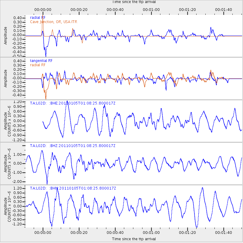
L02D Cave Junction, OR, USA - Earthquake Result Viewer
*The percent match for this event was below the threshold and hence no stack was calculated.
| Earthquake location: |
Southeast Of Honshu, Japan |
| Earthquake latitude/longitude: |
31.5/142.2 |
| Earthquake time(UTC): |
2011/01/05 (005) 00:57:32 GMT |
| Earthquake Depth: |
21 km |
| Earthquake Magnitude: |
6.0 MB, 5.4 MS, 5.6 MW |
| Earthquake Catalog/Contributor: |
WHDF/NEIC |
|
| Network: |
TA USArray Transportable Network (new EarthScope stations) |
| Station: |
L02D Cave Junction, OR, USA |
| Lat/Lon: |
42.16 N/123.60 W |
| Elevation: |
458 m |
|
| Distance: |
72.5 deg |
| Az: |
51.05 deg |
| Baz: |
296.746 deg |
| Ray Param: |
$rayparam |
*The percent match for this event was below the threshold and hence was not used in the summary stack. |
|
| Radial Match: |
66.85984 % |
| Radial Bump: |
400 |
| Transverse Match: |
53.71507 % |
| Transverse Bump: |
400 |
| SOD ConfigId: |
346946 |
| Insert Time: |
2011-07-04 12:52:14.098 +0000 |
| GWidth: |
2.5 |
| Max Bumps: |
400 |
| Tol: |
0.001 |
|
Signal To Noise
| Channel | StoN | STA | LTA |
| TA:L02D: :BHZ:20110105T01:08:25.800017Z | 2.2030745 | 1.0491891E-6 | 4.762386E-7 |
| TA:L02D: :BHN:20110105T01:08:25.800017Z | 2.5431838 | 6.843952E-7 | 2.6910962E-7 |
| TA:L02D: :BHE:20110105T01:08:25.800017Z | 1.2977905 | 6.7637626E-7 | 5.211752E-7 |
| Arrivals |
| Ps | |
| PpPs | |
| PsPs/PpSs | |


