You are here: Home > Network List > AZ - ANZA Regional Network Stations List
> Station FRD AZ.FRD > Earthquake Result Viewer
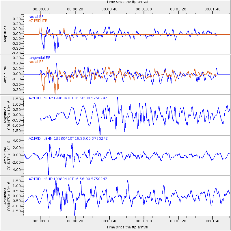
FRD AZ.FRD - Earthquake Result Viewer
*The percent match for this event was below the threshold and hence no stack was calculated.
| Earthquake location: |
South Of Kermadec Islands |
| Earthquake latitude/longitude: |
-33.5/-179.5 |
| Earthquake time(UTC): |
1998/04/10 (100) 16:43:41 GMT |
| Earthquake Depth: |
46 km |
| Earthquake Magnitude: |
5.9 MB, 5.9 MS, 6.0 UNKNOWN, 6.0 MW |
| Earthquake Catalog/Contributor: |
WHDF/NEIC |
|
| Network: |
AZ ANZA Regional Network |
| Station: |
FRD AZ.FRD |
| Lat/Lon: |
33.49 N/116.60 W |
| Elevation: |
1164 m |
|
| Distance: |
89.1 deg |
| Az: |
48.095 deg |
| Baz: |
228.057 deg |
| Ray Param: |
$rayparam |
*The percent match for this event was below the threshold and hence was not used in the summary stack. |
|
| Radial Match: |
75.1529 % |
| Radial Bump: |
400 |
| Transverse Match: |
57.170795 % |
| Transverse Bump: |
400 |
| SOD ConfigId: |
4480 |
| Insert Time: |
2010-02-26 19:20:23.837 +0000 |
| GWidth: |
2.5 |
| Max Bumps: |
400 |
| Tol: |
0.001 |
|
Signal To Noise
| Channel | StoN | STA | LTA |
| AZ:FRD: :BHN:19980410T16:56:00.575024Z | 3.6076891 | 1.4583767E-6 | 4.042412E-7 |
| AZ:FRD: :BHE:19980410T16:56:00.575024Z | 1.3488477 | 5.979181E-7 | 4.4328064E-7 |
| AZ:FRD: :BHZ:19980410T16:56:00.575024Z | 2.0798101 | 8.5483384E-7 | 4.1101535E-7 |
| Arrivals |
| Ps | |
| PpPs | |
| PsPs/PpSs | |


