You are here: Home > Network List > TA - USArray Transportable Network (new EarthScope stations) Stations List
> Station K35A Storm Lake, IA, USA > Earthquake Result Viewer
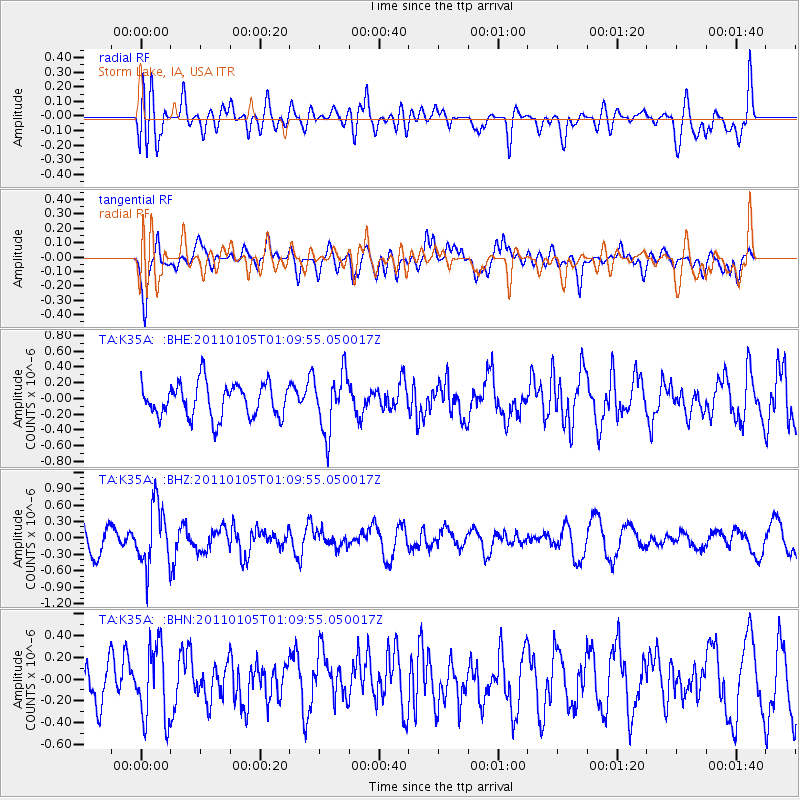
K35A Storm Lake, IA, USA - Earthquake Result Viewer
*The percent match for this event was below the threshold and hence no stack was calculated.
| Earthquake location: |
Southeast Of Honshu, Japan |
| Earthquake latitude/longitude: |
31.5/142.2 |
| Earthquake time(UTC): |
2011/01/05 (005) 00:57:32 GMT |
| Earthquake Depth: |
21 km |
| Earthquake Magnitude: |
6.0 MB, 5.4 MS, 5.6 MW |
| Earthquake Catalog/Contributor: |
WHDF/NEIC |
|
| Network: |
TA USArray Transportable Network (new EarthScope stations) |
| Station: |
K35A Storm Lake, IA, USA |
| Lat/Lon: |
42.72 N/95.23 W |
| Elevation: |
439 m |
|
| Distance: |
89.3 deg |
| Az: |
38.385 deg |
| Baz: |
313.994 deg |
| Ray Param: |
$rayparam |
*The percent match for this event was below the threshold and hence was not used in the summary stack. |
|
| Radial Match: |
55.587708 % |
| Radial Bump: |
400 |
| Transverse Match: |
61.75813 % |
| Transverse Bump: |
400 |
| SOD ConfigId: |
346946 |
| Insert Time: |
2011-07-04 13:07:33.090 +0000 |
| GWidth: |
2.5 |
| Max Bumps: |
400 |
| Tol: |
0.001 |
|
Signal To Noise
| Channel | StoN | STA | LTA |
| TA:K35A: :BHZ:20110105T01:09:55.050017Z | 2.8171551 | 5.5532684E-7 | 1.9712327E-7 |
| TA:K35A: :BHN:20110105T01:09:55.050017Z | 1.4899664 | 3.4127078E-7 | 2.2904597E-7 |
| TA:K35A: :BHE:20110105T01:09:55.050017Z | 1.7255617 | 3.6837952E-7 | 2.1348382E-7 |
| Arrivals |
| Ps | |
| PpPs | |
| PsPs/PpSs | |


