You are here: Home > Network List > XG92 - Rocky Mountain Front Stations List
> Station KRM Kremlin, CO > Earthquake Result Viewer
KRM Kremlin, CO - Earthquake Result Viewer
| Earthquake location: |
South Of Panama |
| Earthquake latitude/longitude: |
6.1/-82.4 |
| Earthquake time(UTC): |
1992/06/26 (178) 11:32:30 GMT |
| Earthquake Depth: |
33 km |
| Earthquake Magnitude: |
5.8 MB, 5.4 MS |
| Earthquake Catalog/Contributor: |
WHDF/NEIC |
|
| Network: |
XG Rocky Mountain Front |
| Station: |
KRM Kremlin, CO |
| Lat/Lon: |
40.13 N/106.40 W |
| Elevation: |
2458 m |
|
| Distance: |
40.1 deg |
| Az: |
331.031 deg |
| Baz: |
141.086 deg |
| Ray Param: |
0.07449884 |
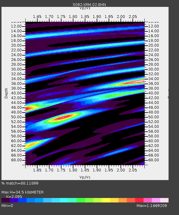
| Estimated Moho Depth: |
34.5 km |
| Estimated Crust Vp/Vs: |
2.10 |
| Assumed Crust Vp: |
6.159 km/s |
| Estimated Crust Vs: |
2.94 km/s |
| Estimated Crust Poisson's Ratio: |
0.35 |
|
| Radial Match: |
88.11899 % |
| Radial Bump: |
324 |
| Transverse Match: |
73.28593 % |
| Transverse Bump: |
400 |
| SOD ConfigId: |
3286 |
| Insert Time: |
2010-02-25 20:09:38.098 +0000 |
| GWidth: |
2.5 |
| Max Bumps: |
400 |
| Tol: |
0.001 |
|

Signal To Noise
| Channel | StoN | STA | LTA |
| XG:KRM:02:BHN:19920626T11:39:32.99801Z | 1.1290332 | 8.373181E-5 | 7.416239E-5 |
| XG:KRM:02:BHE:19920626T11:39:32.99801Z | 1.3653339 | 1.6986519E-4 | 1.2441292E-4 |
| XG:KRM:02:BHZ:19920626T11:39:32.99801Z | 5.7064786 | 1.9415555E-4 | 3.4023706E-5 |
| Arrivals |
| Ps | 6.5 SECOND |
| PpPs | 16 SECOND |
| PsPs/PpSs | 23 SECOND |


