You are here: Home > Network List > US - United States National Seismic Network Stations List
> Station HAWA Hanford, Washington, USA > Earthquake Result Viewer
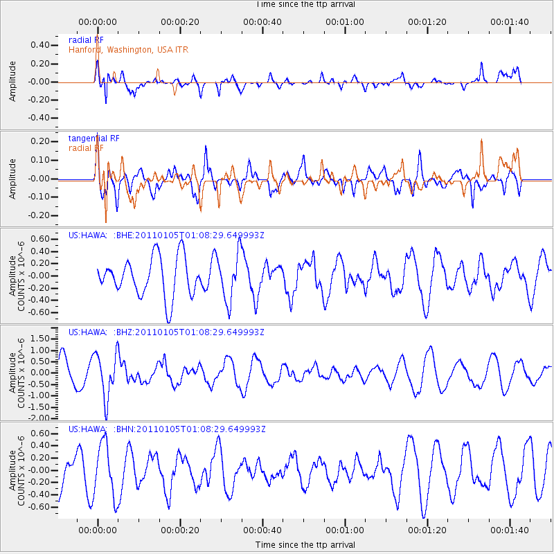
HAWA Hanford, Washington, USA - Earthquake Result Viewer
*The percent match for this event was below the threshold and hence no stack was calculated.
| Earthquake location: |
Southeast Of Honshu, Japan |
| Earthquake latitude/longitude: |
31.5/142.2 |
| Earthquake time(UTC): |
2011/01/05 (005) 00:57:32 GMT |
| Earthquake Depth: |
21 km |
| Earthquake Magnitude: |
6.0 MB, 5.4 MS, 5.6 MW |
| Earthquake Catalog/Contributor: |
WHDF/NEIC |
|
| Network: |
US United States National Seismic Network |
| Station: |
HAWA Hanford, Washington, USA |
| Lat/Lon: |
46.39 N/119.53 W |
| Elevation: |
364 m |
|
| Distance: |
73.1 deg |
| Az: |
45.708 deg |
| Baz: |
297.998 deg |
| Ray Param: |
$rayparam |
*The percent match for this event was below the threshold and hence was not used in the summary stack. |
|
| Radial Match: |
80.40838 % |
| Radial Bump: |
400 |
| Transverse Match: |
56.806244 % |
| Transverse Bump: |
400 |
| SOD ConfigId: |
346946 |
| Insert Time: |
2011-07-04 13:23:54.786 +0000 |
| GWidth: |
2.5 |
| Max Bumps: |
400 |
| Tol: |
0.001 |
|
Signal To Noise
| Channel | StoN | STA | LTA |
| US:HAWA: :BHZ:20110105T01:08:29.649993Z | 1.6202712 | 9.859189E-7 | 6.0849E-7 |
| US:HAWA: :BHN:20110105T01:08:29.649993Z | 1.7740806 | 4.3956103E-7 | 2.4776836E-7 |
| US:HAWA: :BHE:20110105T01:08:29.649993Z | 1.2169886 | 3.8646695E-7 | 3.1756008E-7 |
| Arrivals |
| Ps | |
| PpPs | |
| PsPs/PpSs | |


