You are here: Home > Network List > US - United States National Seismic Network Stations List
> Station DGMT Dagmar, Montana, USA > Earthquake Result Viewer
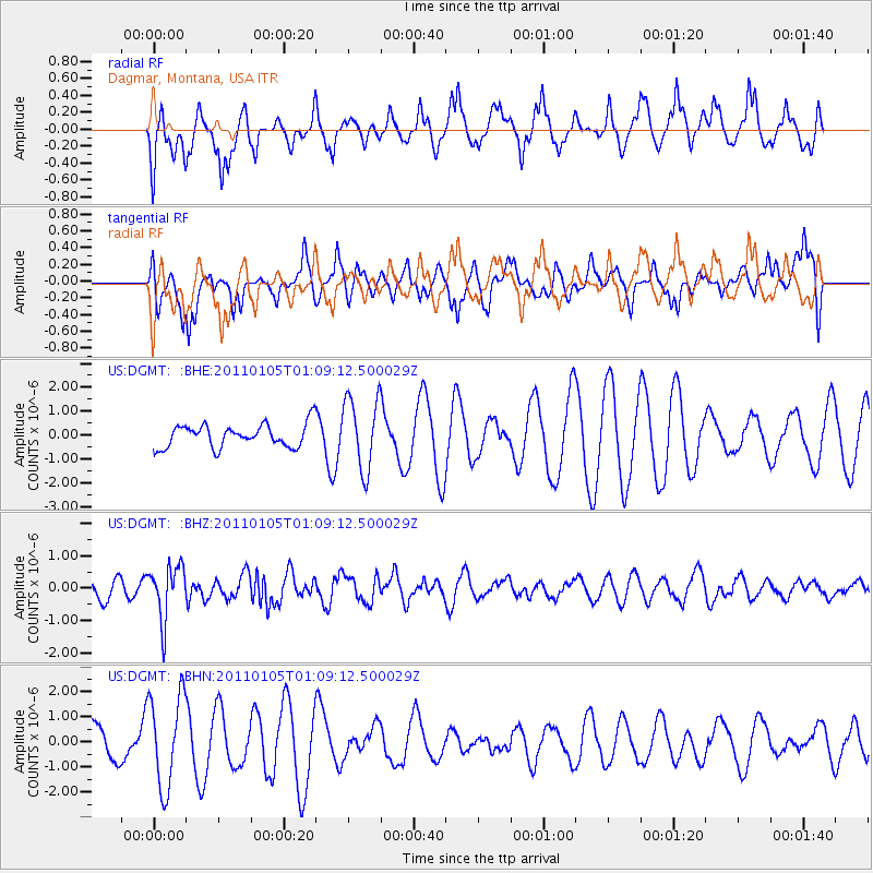
DGMT Dagmar, Montana, USA - Earthquake Result Viewer
*The percent match for this event was below the threshold and hence no stack was calculated.
| Earthquake location: |
Southeast Of Honshu, Japan |
| Earthquake latitude/longitude: |
31.5/142.2 |
| Earthquake time(UTC): |
2011/01/05 (005) 00:57:32 GMT |
| Earthquake Depth: |
21 km |
| Earthquake Magnitude: |
6.0 MB, 5.4 MS, 5.6 MW |
| Earthquake Catalog/Contributor: |
WHDF/NEIC |
|
| Network: |
US United States National Seismic Network |
| Station: |
DGMT Dagmar, Montana, USA |
| Lat/Lon: |
48.47 N/104.20 W |
| Elevation: |
0.0 m |
|
| Distance: |
80.7 deg |
| Az: |
38.153 deg |
| Baz: |
307.577 deg |
| Ray Param: |
$rayparam |
*The percent match for this event was below the threshold and hence was not used in the summary stack. |
|
| Radial Match: |
51.061237 % |
| Radial Bump: |
385 |
| Transverse Match: |
31.41279 % |
| Transverse Bump: |
400 |
| SOD ConfigId: |
346946 |
| Insert Time: |
2011-07-04 13:25:01.976 +0000 |
| GWidth: |
2.5 |
| Max Bumps: |
400 |
| Tol: |
0.001 |
|
Signal To Noise
| Channel | StoN | STA | LTA |
| US:DGMT: :BHZ:20110105T01:09:12.500029Z | 3.1128724 | 8.3674576E-7 | 2.688018E-7 |
| US:DGMT: :BHN:20110105T01:09:12.500029Z | 2.4108431 | 1.8422036E-6 | 7.641325E-7 |
| US:DGMT: :BHE:20110105T01:09:12.500029Z | 3.1253922 | 1.504977E-6 | 4.815322E-7 |
| Arrivals |
| Ps | |
| PpPs | |
| PsPs/PpSs | |


