You are here: Home > Network List > US - United States National Seismic Network Stations List
> Station EGMT Eagleton, Montana, USA > Earthquake Result Viewer
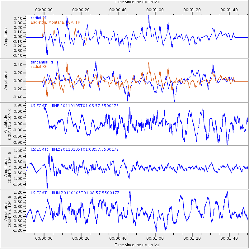
EGMT Eagleton, Montana, USA - Earthquake Result Viewer
*The percent match for this event was below the threshold and hence no stack was calculated.
| Earthquake location: |
Southeast Of Honshu, Japan |
| Earthquake latitude/longitude: |
31.5/142.2 |
| Earthquake time(UTC): |
2011/01/05 (005) 00:57:32 GMT |
| Earthquake Depth: |
21 km |
| Earthquake Magnitude: |
6.0 MB, 5.4 MS, 5.6 MW |
| Earthquake Catalog/Contributor: |
WHDF/NEIC |
|
| Network: |
US United States National Seismic Network |
| Station: |
EGMT Eagleton, Montana, USA |
| Lat/Lon: |
48.02 N/109.75 W |
| Elevation: |
1055 m |
|
| Distance: |
78.0 deg |
| Az: |
40.729 deg |
| Baz: |
303.916 deg |
| Ray Param: |
$rayparam |
*The percent match for this event was below the threshold and hence was not used in the summary stack. |
|
| Radial Match: |
66.628624 % |
| Radial Bump: |
400 |
| Transverse Match: |
44.723988 % |
| Transverse Bump: |
400 |
| SOD ConfigId: |
346946 |
| Insert Time: |
2011-07-04 13:25:43.686 +0000 |
| GWidth: |
2.5 |
| Max Bumps: |
400 |
| Tol: |
0.001 |
|
Signal To Noise
| Channel | StoN | STA | LTA |
| US:EGMT: :BHZ:20110105T01:08:57.550017Z | 3.421059 | 7.264315E-7 | 2.1234113E-7 |
| US:EGMT: :BHN:20110105T01:08:57.550017Z | 1.0575598 | 3.92175E-7 | 3.708301E-7 |
| US:EGMT: :BHE:20110105T01:08:57.550017Z | 0.56835765 | 1.8982689E-7 | 3.3399198E-7 |
| Arrivals |
| Ps | |
| PpPs | |
| PsPs/PpSs | |


