You are here: Home > Network List > BK - Berkeley Digital Seismograph Network Stations List
> Station HUMO Hull Mountain, OR > Earthquake Result Viewer
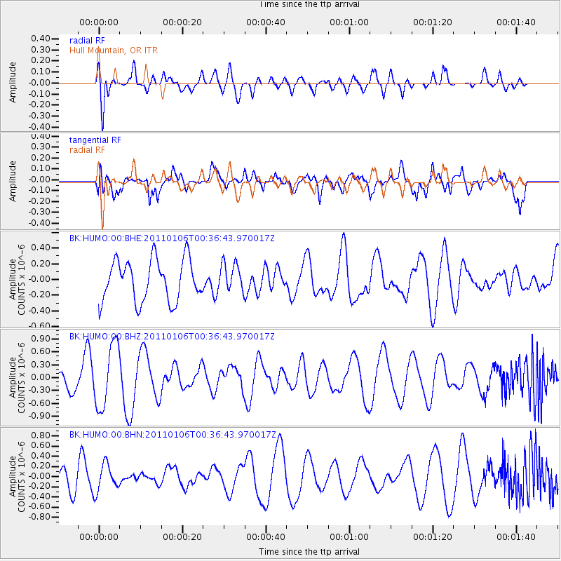
HUMO Hull Mountain, OR - Earthquake Result Viewer
*The percent match for this event was below the threshold and hence no stack was calculated.
| Earthquake location: |
New Guinea, Papua New Guinea |
| Earthquake latitude/longitude: |
-4.1/142.2 |
| Earthquake time(UTC): |
2011/01/06 (006) 00:23:59 GMT |
| Earthquake Depth: |
113 km |
| Earthquake Magnitude: |
5.5 MB, 5.3 MW |
| Earthquake Catalog/Contributor: |
WHDF/NEIC |
|
| Network: |
BK Berkeley Digital Seismograph Network |
| Station: |
HUMO Hull Mountain, OR |
| Lat/Lon: |
42.61 N/122.96 W |
| Elevation: |
555 m |
|
| Distance: |
96.3 deg |
| Az: |
47.744 deg |
| Baz: |
270.213 deg |
| Ray Param: |
$rayparam |
*The percent match for this event was below the threshold and hence was not used in the summary stack. |
|
| Radial Match: |
45.423172 % |
| Radial Bump: |
400 |
| Transverse Match: |
62.715485 % |
| Transverse Bump: |
400 |
| SOD ConfigId: |
346946 |
| Insert Time: |
2011-07-04 13:35:10.659 +0000 |
| GWidth: |
2.5 |
| Max Bumps: |
400 |
| Tol: |
0.001 |
|
Signal To Noise
| Channel | StoN | STA | LTA |
| BK:HUMO:00:BHZ:20110106T00:36:43.970017Z | 4.191755 | 7.507397E-7 | 1.7909915E-7 |
| BK:HUMO:00:BHN:20110106T00:36:43.970017Z | 0.7985077 | 2.5825923E-7 | 3.2342737E-7 |
| BK:HUMO:00:BHE:20110106T00:36:43.970017Z | 0.68302274 | 1.794088E-7 | 2.6266886E-7 |
| Arrivals |
| Ps | |
| PpPs | |
| PsPs/PpSs | |


