You are here: Home > Network List > BK - Berkeley Digital Seismograph Network Stations List
> Station HUMO Hull Mountain, OR > Earthquake Result Viewer
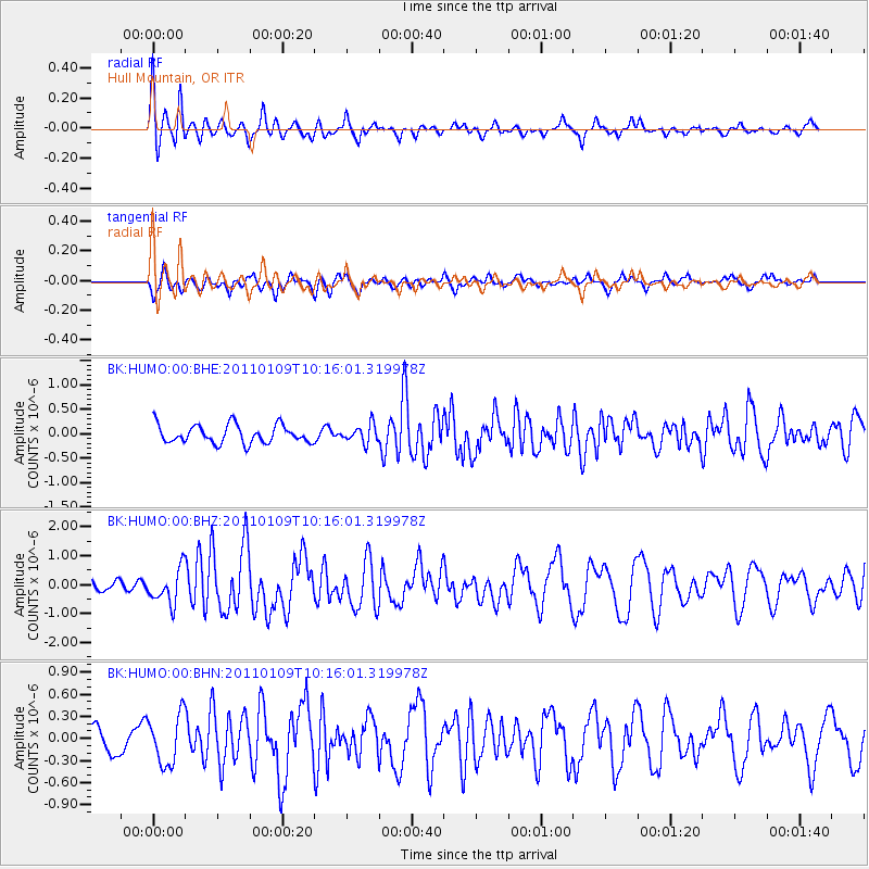
HUMO Hull Mountain, OR - Earthquake Result Viewer
*The percent match for this event was below the threshold and hence no stack was calculated.
| Earthquake location: |
Vanuatu Islands |
| Earthquake latitude/longitude: |
-19.2/168.3 |
| Earthquake time(UTC): |
2011/01/09 (009) 10:03:44 GMT |
| Earthquake Depth: |
24 km |
| Earthquake Magnitude: |
6.1 MB, 6.4 MS, 6.6 MW, 6.5 MW |
| Earthquake Catalog/Contributor: |
WHDF/NEIC |
|
| Network: |
BK Berkeley Digital Seismograph Network |
| Station: |
HUMO Hull Mountain, OR |
| Lat/Lon: |
42.61 N/122.96 W |
| Elevation: |
555 m |
|
| Distance: |
88.1 deg |
| Az: |
43.501 deg |
| Baz: |
241.813 deg |
| Ray Param: |
$rayparam |
*The percent match for this event was below the threshold and hence was not used in the summary stack. |
|
| Radial Match: |
77.9549 % |
| Radial Bump: |
384 |
| Transverse Match: |
70.79617 % |
| Transverse Bump: |
370 |
| SOD ConfigId: |
346946 |
| Insert Time: |
2011-07-09 07:08:09.898 +0000 |
| GWidth: |
2.5 |
| Max Bumps: |
400 |
| Tol: |
0.001 |
|
Signal To Noise
| Channel | StoN | STA | LTA |
| BK:HUMO:00:BHZ:20110109T10:16:01.319978Z | 2.3485956 | 5.947593E-7 | 2.532404E-7 |
| BK:HUMO:00:BHN:20110109T10:16:01.319978Z | 1.2686688 | 3.3527778E-7 | 2.6427526E-7 |
| BK:HUMO:00:BHE:20110109T10:16:01.319978Z | 0.9742687 | 1.8159666E-7 | 1.863928E-7 |
| Arrivals |
| Ps | |
| PpPs | |
| PsPs/PpSs | |


