You are here: Home > Network List > TA - USArray Transportable Network (new EarthScope stations) Stations List
> Station J05D Fort Rock, OR, USA > Earthquake Result Viewer
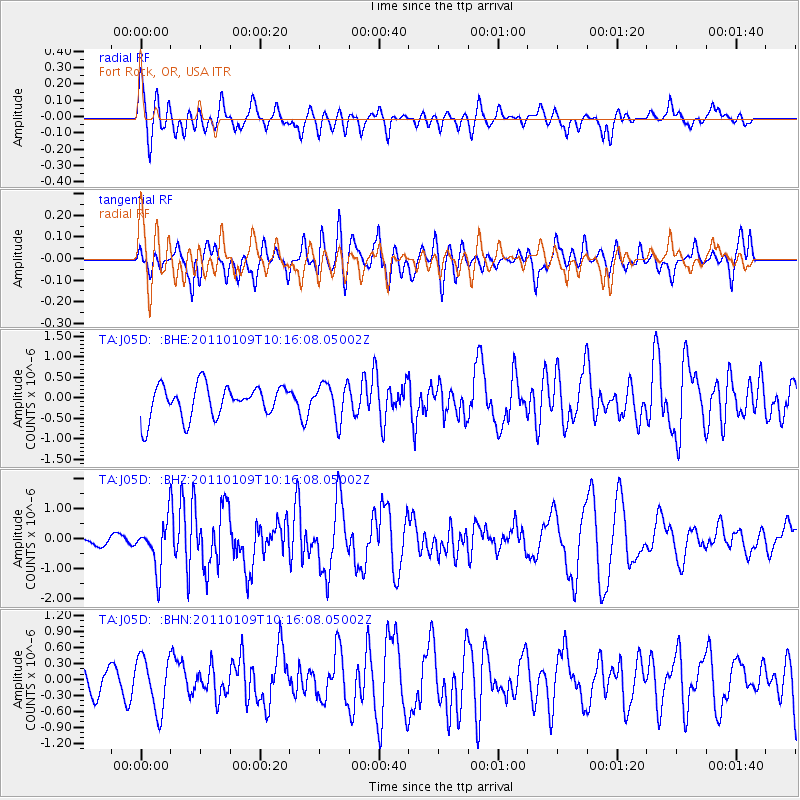
J05D Fort Rock, OR, USA - Earthquake Result Viewer
*The percent match for this event was below the threshold and hence no stack was calculated.
| Earthquake location: |
Vanuatu Islands |
| Earthquake latitude/longitude: |
-19.2/168.3 |
| Earthquake time(UTC): |
2011/01/09 (009) 10:03:44 GMT |
| Earthquake Depth: |
24 km |
| Earthquake Magnitude: |
6.1 MB, 6.4 MS, 6.6 MW, 6.5 MW |
| Earthquake Catalog/Contributor: |
WHDF/NEIC |
|
| Network: |
TA USArray Transportable Network (new EarthScope stations) |
| Station: |
J05D Fort Rock, OR, USA |
| Lat/Lon: |
43.28 N/121.23 W |
| Elevation: |
1541 m |
|
| Distance: |
89.5 deg |
| Az: |
43.487 deg |
| Baz: |
242.981 deg |
| Ray Param: |
$rayparam |
*The percent match for this event was below the threshold and hence was not used in the summary stack. |
|
| Radial Match: |
57.8025 % |
| Radial Bump: |
400 |
| Transverse Match: |
62.168392 % |
| Transverse Bump: |
400 |
| SOD ConfigId: |
346946 |
| Insert Time: |
2011-07-09 07:24:05.115 +0000 |
| GWidth: |
2.5 |
| Max Bumps: |
400 |
| Tol: |
0.001 |
|
Signal To Noise
| Channel | StoN | STA | LTA |
| TA:J05D: :BHZ:20110109T10:16:08.05002Z | 1.818618 | 7.7986175E-7 | 4.288211E-7 |
| TA:J05D: :BHN:20110109T10:16:08.05002Z | 1.4060827 | 5.0306033E-7 | 3.577743E-7 |
| TA:J05D: :BHE:20110109T10:16:08.05002Z | 1.129491 | 4.4188798E-7 | 3.9122756E-7 |
| Arrivals |
| Ps | |
| PpPs | |
| PsPs/PpSs | |


