You are here: Home > Network List > TA - USArray Transportable Network (new EarthScope stations) Stations List
> Station G03D McMinnville, OR, USA > Earthquake Result Viewer
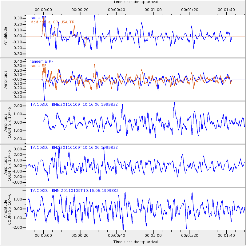
G03D McMinnville, OR, USA - Earthquake Result Viewer
*The percent match for this event was below the threshold and hence no stack was calculated.
| Earthquake location: |
Vanuatu Islands |
| Earthquake latitude/longitude: |
-19.2/168.3 |
| Earthquake time(UTC): |
2011/01/09 (009) 10:03:44 GMT |
| Earthquake Depth: |
24 km |
| Earthquake Magnitude: |
6.1 MB, 6.4 MS, 6.6 MW, 6.5 MW |
| Earthquake Catalog/Contributor: |
WHDF/NEIC |
|
| Network: |
TA USArray Transportable Network (new EarthScope stations) |
| Station: |
G03D McMinnville, OR, USA |
| Lat/Lon: |
45.21 N/123.26 W |
| Elevation: |
222 m |
|
| Distance: |
89.1 deg |
| Az: |
41.103 deg |
| Baz: |
241.542 deg |
| Ray Param: |
$rayparam |
*The percent match for this event was below the threshold and hence was not used in the summary stack. |
|
| Radial Match: |
67.463875 % |
| Radial Bump: |
400 |
| Transverse Match: |
65.951355 % |
| Transverse Bump: |
400 |
| SOD ConfigId: |
346946 |
| Insert Time: |
2011-07-09 07:24:26.606 +0000 |
| GWidth: |
2.5 |
| Max Bumps: |
400 |
| Tol: |
0.001 |
|
Signal To Noise
| Channel | StoN | STA | LTA |
| TA:G03D: :BHZ:20110109T10:16:06.199983Z | 3.081568 | 1.1843731E-6 | 3.8434106E-7 |
| TA:G03D: :BHN:20110109T10:16:06.199983Z | 1.798261 | 8.2018767E-7 | 4.5610042E-7 |
| TA:G03D: :BHE:20110109T10:16:06.199983Z | 1.1158438 | 5.8589865E-7 | 5.2507227E-7 |
| Arrivals |
| Ps | |
| PpPs | |
| PsPs/PpSs | |


