You are here: Home > Network List > AZ - ANZA Regional Network Stations List
> Station FRD AZ.FRD > Earthquake Result Viewer
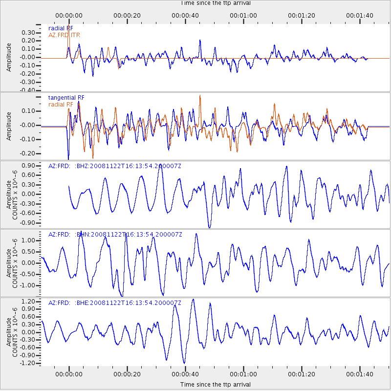
FRD AZ.FRD - Earthquake Result Viewer
*The percent match for this event was below the threshold and hence no stack was calculated.
| Earthquake location: |
Southeast Of Loyalty Islands |
| Earthquake latitude/longitude: |
-22.5/171.2 |
| Earthquake time(UTC): |
2008/11/22 (327) 16:01:39 GMT |
| Earthquake Depth: |
57 km |
| Earthquake Magnitude: |
5.7 MB, 6.4 MW, 6.4 MW |
| Earthquake Catalog/Contributor: |
WHDF/NEIC |
|
| Network: |
AZ ANZA Regional Network |
| Station: |
FRD AZ.FRD |
| Lat/Lon: |
33.49 N/116.60 W |
| Elevation: |
1164 m |
|
| Distance: |
88.5 deg |
| Az: |
52.742 deg |
| Baz: |
241.725 deg |
| Ray Param: |
$rayparam |
*The percent match for this event was below the threshold and hence was not used in the summary stack. |
|
| Radial Match: |
54.1897 % |
| Radial Bump: |
400 |
| Transverse Match: |
43.269875 % |
| Transverse Bump: |
400 |
| SOD ConfigId: |
2658 |
| Insert Time: |
2010-02-26 19:21:04.020 +0000 |
| GWidth: |
2.5 |
| Max Bumps: |
400 |
| Tol: |
0.001 |
|
Signal To Noise
| Channel | StoN | STA | LTA |
| AZ:FRD: :BHN:20081122T16:13:54.200007Z | 3.8176355 | 7.370826E-7 | 1.9307308E-7 |
| AZ:FRD: :BHE:20081122T16:13:54.200007Z | 0.9885924 | 2.5967435E-7 | 2.626708E-7 |
| AZ:FRD: :BHZ:20081122T16:13:54.200007Z | 1.7535207 | 5.7228954E-7 | 3.26366E-7 |
| Arrivals |
| Ps | |
| PpPs | |
| PsPs/PpSs | |


