You are here: Home > Network List > TA - USArray Transportable Network (new EarthScope stations) Stations List
> Station I30A Oacoma, SD, USA > Earthquake Result Viewer
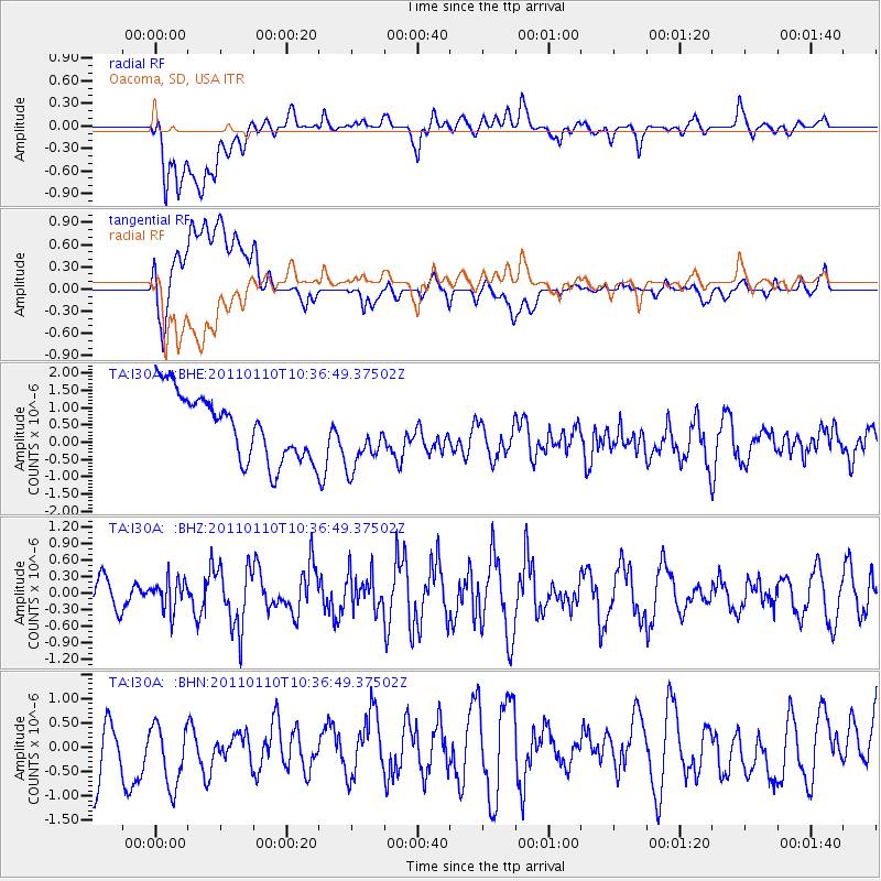
I30A Oacoma, SD, USA - Earthquake Result Viewer
*The percent match for this event was below the threshold and hence no stack was calculated.
| Earthquake location: |
Volcano Islands, Japan Region |
| Earthquake latitude/longitude: |
23.1/143.2 |
| Earthquake time(UTC): |
2011/01/10 (010) 10:24:20 GMT |
| Earthquake Depth: |
87 km |
| Earthquake Magnitude: |
5.7 MB, 5.6 MW, 5.6 MW |
| Earthquake Catalog/Contributor: |
WHDF/NEIC |
|
| Network: |
TA USArray Transportable Network (new EarthScope stations) |
| Station: |
I30A Oacoma, SD, USA |
| Lat/Lon: |
43.91 N/99.43 W |
| Elevation: |
549 m |
|
| Distance: |
92.1 deg |
| Az: |
39.942 deg |
| Baz: |
305.108 deg |
| Ray Param: |
$rayparam |
*The percent match for this event was below the threshold and hence was not used in the summary stack. |
|
| Radial Match: |
57.544895 % |
| Radial Bump: |
400 |
| Transverse Match: |
49.811237 % |
| Transverse Bump: |
400 |
| SOD ConfigId: |
346946 |
| Insert Time: |
2011-07-09 08:18:38.216 +0000 |
| GWidth: |
2.5 |
| Max Bumps: |
400 |
| Tol: |
0.001 |
|
Signal To Noise
| Channel | StoN | STA | LTA |
| TA:I30A: :BHZ:20110110T10:36:49.37502Z | 1.011551 | 2.7728035E-7 | 2.7411406E-7 |
| TA:I30A: :BHN:20110110T10:36:49.37502Z | 1.3916924 | 7.4894155E-7 | 5.381516E-7 |
| TA:I30A: :BHE:20110110T10:36:49.37502Z | 0.9646247 | 9.164627E-7 | 9.5007175E-7 |
| Arrivals |
| Ps | |
| PpPs | |
| PsPs/PpSs | |


