You are here: Home > Network List > TA - USArray Transportable Network (new EarthScope stations) Stations List
> Station G36A St. Michael, MN, USA > Earthquake Result Viewer
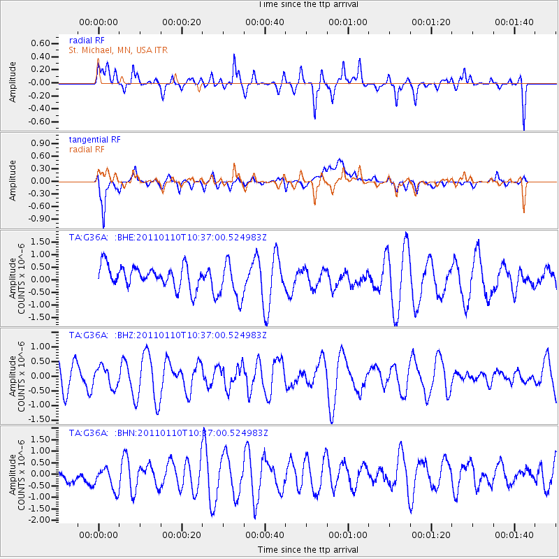
G36A St. Michael, MN, USA - Earthquake Result Viewer
*The percent match for this event was below the threshold and hence no stack was calculated.
| Earthquake location: |
Volcano Islands, Japan Region |
| Earthquake latitude/longitude: |
23.1/143.2 |
| Earthquake time(UTC): |
2011/01/10 (010) 10:24:20 GMT |
| Earthquake Depth: |
87 km |
| Earthquake Magnitude: |
5.7 MB, 5.6 MW, 5.6 MW |
| Earthquake Catalog/Contributor: |
WHDF/NEIC |
|
| Network: |
TA USArray Transportable Network (new EarthScope stations) |
| Station: |
G36A St. Michael, MN, USA |
| Lat/Lon: |
45.23 N/93.75 W |
| Elevation: |
293 m |
|
| Distance: |
94.5 deg |
| Az: |
36.435 deg |
| Baz: |
309.283 deg |
| Ray Param: |
$rayparam |
*The percent match for this event was below the threshold and hence was not used in the summary stack. |
|
| Radial Match: |
64.0281 % |
| Radial Bump: |
400 |
| Transverse Match: |
67.3683 % |
| Transverse Bump: |
400 |
| SOD ConfigId: |
346946 |
| Insert Time: |
2011-07-09 08:20:42.309 +0000 |
| GWidth: |
2.5 |
| Max Bumps: |
400 |
| Tol: |
0.001 |
|
Signal To Noise
| Channel | StoN | STA | LTA |
| TA:G36A: :BHZ:20110110T10:37:00.524983Z | 0.9280912 | 3.463428E-7 | 3.7317756E-7 |
| TA:G36A: :BHN:20110110T10:37:00.524983Z | 0.91230375 | 6.1909975E-7 | 6.786114E-7 |
| TA:G36A: :BHE:20110110T10:37:00.524983Z | 1.791541 | 7.6439386E-7 | 4.2666838E-7 |
| Arrivals |
| Ps | |
| PpPs | |
| PsPs/PpSs | |


