You are here: Home > Network List > CI - Caltech Regional Seismic Network Stations List
> Station LGU LGU, Camarillo, CA, USA > Earthquake Result Viewer
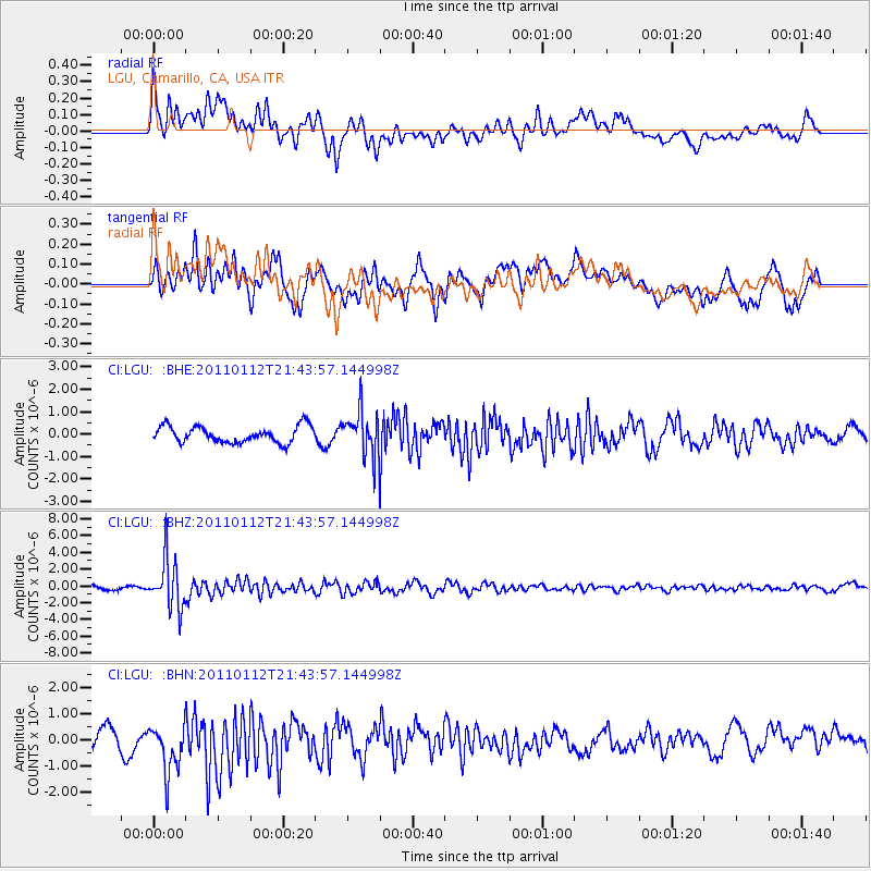
LGU LGU, Camarillo, CA, USA - Earthquake Result Viewer
*The percent match for this event was below the threshold and hence no stack was calculated.
| Earthquake location: |
Bonin Islands, Japan Region |
| Earthquake latitude/longitude: |
27.0/139.9 |
| Earthquake time(UTC): |
2011/01/12 (012) 21:32:55 GMT |
| Earthquake Depth: |
528 km |
| Earthquake Magnitude: |
6.2 MB, 6.5 MW, 6.5 MW |
| Earthquake Catalog/Contributor: |
WHDF/NEIC |
|
| Network: |
CI Caltech Regional Seismic Network |
| Station: |
LGU LGU, Camarillo, CA, USA |
| Lat/Lon: |
34.11 N/119.07 W |
| Elevation: |
416 m |
|
| Distance: |
83.7 deg |
| Az: |
55.01 deg |
| Baz: |
298.22 deg |
| Ray Param: |
$rayparam |
*The percent match for this event was below the threshold and hence was not used in the summary stack. |
|
| Radial Match: |
59.915905 % |
| Radial Bump: |
400 |
| Transverse Match: |
58.50876 % |
| Transverse Bump: |
400 |
| SOD ConfigId: |
346946 |
| Insert Time: |
2011-07-09 08:50:24.354 +0000 |
| GWidth: |
2.5 |
| Max Bumps: |
400 |
| Tol: |
0.001 |
|
Signal To Noise
| Channel | StoN | STA | LTA |
| CI:LGU: :BHZ:20110112T21:43:57.144998Z | 7.676534 | 2.9498483E-6 | 3.8426825E-7 |
| CI:LGU: :BHN:20110112T21:43:57.144998Z | 2.6733434 | 1.0180768E-6 | 3.808253E-7 |
| CI:LGU: :BHE:20110112T21:43:57.144998Z | 2.7599878 | 1.0017175E-6 | 3.6294273E-7 |
| Arrivals |
| Ps | |
| PpPs | |
| PsPs/PpSs | |


