You are here: Home > Network List > CI - Caltech Regional Seismic Network Stations List
> Station RCT Rector, Visalia, CA, USA > Earthquake Result Viewer
RCT Rector, Visalia, CA, USA - Earthquake Result Viewer
| Earthquake location: |
Bonin Islands, Japan Region |
| Earthquake latitude/longitude: |
27.0/139.9 |
| Earthquake time(UTC): |
2011/01/12 (012) 21:32:55 GMT |
| Earthquake Depth: |
528 km |
| Earthquake Magnitude: |
6.2 MB, 6.5 MW, 6.5 MW |
| Earthquake Catalog/Contributor: |
WHDF/NEIC |
|
| Network: |
CI Caltech Regional Seismic Network |
| Station: |
RCT Rector, Visalia, CA, USA |
| Lat/Lon: |
36.31 N/119.24 W |
| Elevation: |
107 m |
|
| Distance: |
82.5 deg |
| Az: |
53.13 deg |
| Baz: |
297.892 deg |
| Ray Param: |
0.0452831 |
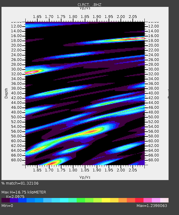
| Estimated Moho Depth: |
16.75 km |
| Estimated Crust Vp/Vs: |
2.10 |
| Assumed Crust Vp: |
6.291 km/s |
| Estimated Crust Vs: |
2.999 km/s |
| Estimated Crust Poisson's Ratio: |
0.35 |
|
| Radial Match: |
81.32106 % |
| Radial Bump: |
400 |
| Transverse Match: |
69.69206 % |
| Transverse Bump: |
400 |
| SOD ConfigId: |
346946 |
| Insert Time: |
2011-07-09 08:51:03.770 +0000 |
| GWidth: |
2.5 |
| Max Bumps: |
400 |
| Tol: |
0.001 |
|
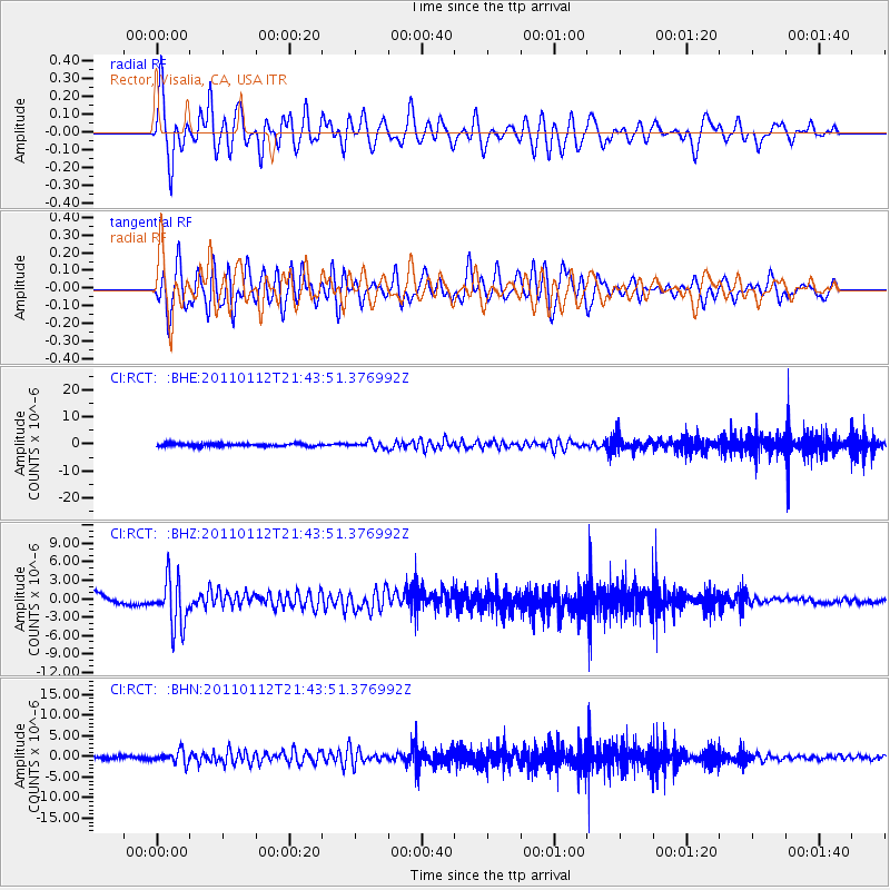
Signal To Noise
| Channel | StoN | STA | LTA |
| CI:RCT: :BHZ:20110112T21:43:51.376992Z | 4.3730226 | 3.905948E-6 | 8.931917E-7 |
| CI:RCT: :BHN:20110112T21:43:51.376992Z | 2.084072 | 1.4622143E-6 | 7.0161406E-7 |
| CI:RCT: :BHE:20110112T21:43:51.376992Z | 2.3887837 | 1.1631432E-6 | 4.869186E-7 |
| Arrivals |
| Ps | 3.0 SECOND |
| PpPs | 8.1 SECOND |
| PsPs/PpSs | 11 SECOND |


