You are here: Home > Network List > CI - Caltech Regional Seismic Network Stations List
> Station SMM Simmler, CA, USA > Earthquake Result Viewer
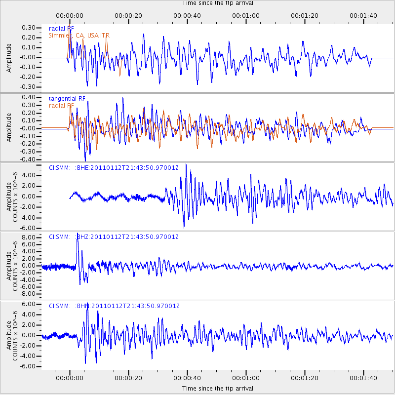
SMM Simmler, CA, USA - Earthquake Result Viewer
*The percent match for this event was below the threshold and hence no stack was calculated.
| Earthquake location: |
Bonin Islands, Japan Region |
| Earthquake latitude/longitude: |
27.0/139.9 |
| Earthquake time(UTC): |
2011/01/12 (012) 21:32:55 GMT |
| Earthquake Depth: |
528 km |
| Earthquake Magnitude: |
6.2 MB, 6.5 MW, 6.5 MW |
| Earthquake Catalog/Contributor: |
WHDF/NEIC |
|
| Network: |
CI Caltech Regional Seismic Network |
| Station: |
SMM Simmler, CA, USA |
| Lat/Lon: |
35.31 N/120.00 W |
| Elevation: |
599 m |
|
| Distance: |
82.5 deg |
| Az: |
54.3 deg |
| Baz: |
297.607 deg |
| Ray Param: |
$rayparam |
*The percent match for this event was below the threshold and hence was not used in the summary stack. |
|
| Radial Match: |
69.57149 % |
| Radial Bump: |
400 |
| Transverse Match: |
72.21283 % |
| Transverse Bump: |
400 |
| SOD ConfigId: |
346946 |
| Insert Time: |
2011-07-09 08:51:29.991 +0000 |
| GWidth: |
2.5 |
| Max Bumps: |
400 |
| Tol: |
0.001 |
|
Signal To Noise
| Channel | StoN | STA | LTA |
| CI:SMM: :BHZ:20110112T21:43:50.97001Z | 8.845689 | 3.1122638E-6 | 3.5183962E-7 |
| CI:SMM: :BHN:20110112T21:43:50.97001Z | 2.8208444 | 9.53825E-7 | 3.3813456E-7 |
| CI:SMM: :BHE:20110112T21:43:50.97001Z | 1.5480405 | 6.510709E-7 | 4.2057744E-7 |
| Arrivals |
| Ps | |
| PpPs | |
| PsPs/PpSs | |


