You are here: Home > Network List > CI - Caltech Regional Seismic Network Stations List
> Station MUR Murrieta > Earthquake Result Viewer
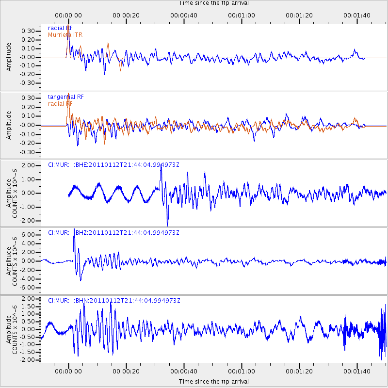
MUR Murrieta - Earthquake Result Viewer
*The percent match for this event was below the threshold and hence no stack was calculated.
| Earthquake location: |
Bonin Islands, Japan Region |
| Earthquake latitude/longitude: |
27.0/139.9 |
| Earthquake time(UTC): |
2011/01/12 (012) 21:32:55 GMT |
| Earthquake Depth: |
528 km |
| Earthquake Magnitude: |
6.2 MB, 6.5 MW, 6.5 MW |
| Earthquake Catalog/Contributor: |
WHDF/NEIC |
|
| Network: |
CI Caltech Regional Seismic Network |
| Station: |
MUR Murrieta |
| Lat/Lon: |
33.60 N/117.20 W |
| Elevation: |
562 m |
|
| Distance: |
85.3 deg |
| Az: |
54.705 deg |
| Baz: |
299.228 deg |
| Ray Param: |
$rayparam |
*The percent match for this event was below the threshold and hence was not used in the summary stack. |
|
| Radial Match: |
73.12402 % |
| Radial Bump: |
400 |
| Transverse Match: |
75.2839 % |
| Transverse Bump: |
400 |
| SOD ConfigId: |
346946 |
| Insert Time: |
2011-07-09 08:55:09.971 +0000 |
| GWidth: |
2.5 |
| Max Bumps: |
400 |
| Tol: |
0.001 |
|
Signal To Noise
| Channel | StoN | STA | LTA |
| CI:MUR: :BHZ:20110112T21:44:04.994973Z | 7.547392 | 2.5587863E-6 | 3.390292E-7 |
| CI:MUR: :BHN:20110112T21:44:04.994973Z | 1.7586356 | 6.6320916E-7 | 3.7711573E-7 |
| CI:MUR: :BHE:20110112T21:44:04.994973Z | 2.5662706 | 9.270575E-7 | 3.6124698E-7 |
| Arrivals |
| Ps | |
| PpPs | |
| PsPs/PpSs | |


