You are here: Home > Network List > GE - GEOFON Stations List
> Station UGM GEOFON Station Wanagama, Indonesia > Earthquake Result Viewer
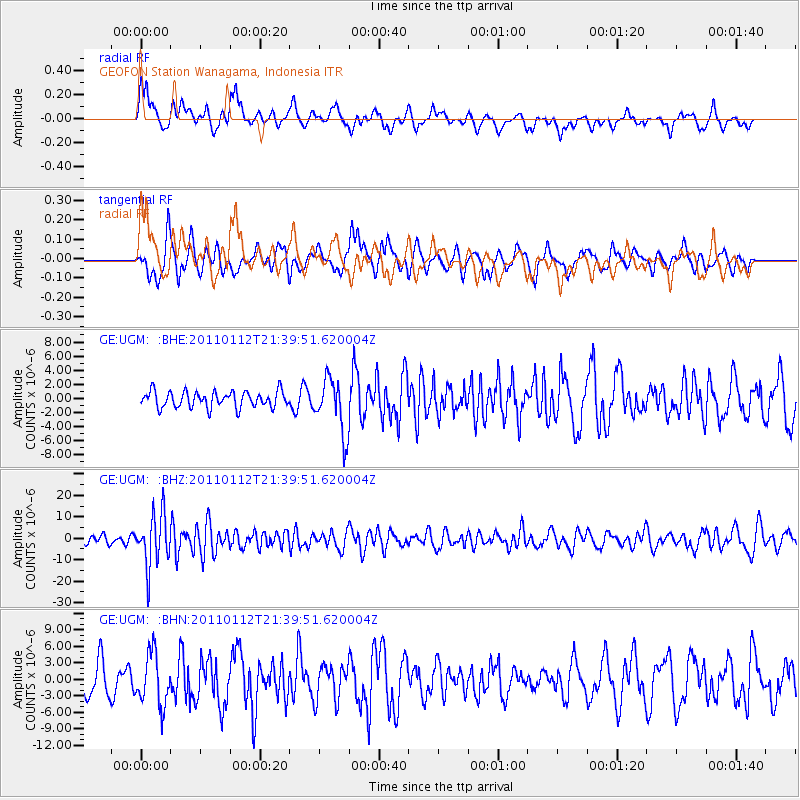
UGM GEOFON Station Wanagama, Indonesia - Earthquake Result Viewer
*The percent match for this event was below the threshold and hence no stack was calculated.
| Earthquake location: |
Bonin Islands, Japan Region |
| Earthquake latitude/longitude: |
27.0/139.9 |
| Earthquake time(UTC): |
2011/01/12 (012) 21:32:55 GMT |
| Earthquake Depth: |
528 km |
| Earthquake Magnitude: |
6.2 MB, 6.5 MW, 6.5 MW |
| Earthquake Catalog/Contributor: |
WHDF/NEIC |
|
| Network: |
GE GEOFON |
| Station: |
UGM GEOFON Station Wanagama, Indonesia |
| Lat/Lon: |
7.91 S/110.52 E |
| Elevation: |
350 m |
|
| Distance: |
44.9 deg |
| Az: |
223.495 deg |
| Baz: |
38.321 deg |
| Ray Param: |
$rayparam |
*The percent match for this event was below the threshold and hence was not used in the summary stack. |
|
| Radial Match: |
66.90543 % |
| Radial Bump: |
388 |
| Transverse Match: |
65.88778 % |
| Transverse Bump: |
400 |
| SOD ConfigId: |
346946 |
| Insert Time: |
2011-07-09 08:57:09.343 +0000 |
| GWidth: |
2.5 |
| Max Bumps: |
400 |
| Tol: |
0.001 |
|
Signal To Noise
| Channel | StoN | STA | LTA |
| GE:UGM: :BHZ:20110112T21:39:51.620004Z | 3.9623287 | 1.206485E-5 | 3.0448887E-6 |
| GE:UGM: :BHN:20110112T21:39:51.620004Z | 1.4121166 | 4.719626E-6 | 3.3422352E-6 |
| GE:UGM: :BHE:20110112T21:39:51.620004Z | 3.3535762 | 3.8187814E-6 | 1.1387191E-6 |
| Arrivals |
| Ps | |
| PpPs | |
| PsPs/PpSs | |


