You are here: Home > Network List > IU - Global Seismograph Network (GSN - IRIS/USGS) Stations List
> Station SLBS Sierra la Laguna Baja California Sur, Mexico > Earthquake Result Viewer
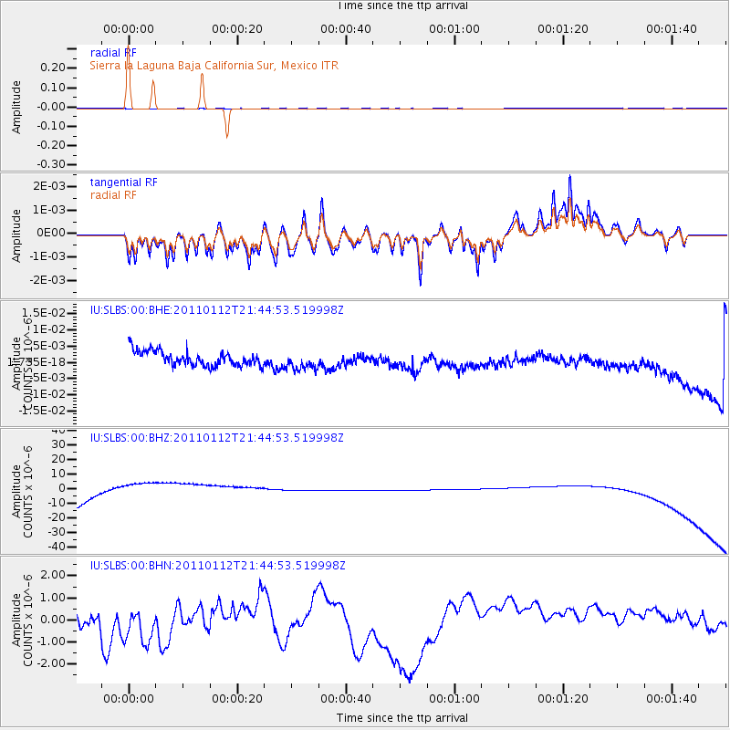
SLBS Sierra la Laguna Baja California Sur, Mexico - Earthquake Result Viewer
*The percent match for this event was below the threshold and hence no stack was calculated.
| Earthquake location: |
Bonin Islands, Japan Region |
| Earthquake latitude/longitude: |
27.0/139.9 |
| Earthquake time(UTC): |
2011/01/12 (012) 21:32:55 GMT |
| Earthquake Depth: |
528 km |
| Earthquake Magnitude: |
6.2 MB, 6.5 MW, 6.5 MW |
| Earthquake Catalog/Contributor: |
WHDF/NEIC |
|
| Network: |
IU Global Seismograph Network (GSN - IRIS/USGS) |
| Station: |
SLBS Sierra la Laguna Baja California Sur, Mexico |
| Lat/Lon: |
23.69 N/109.94 W |
| Elevation: |
825 m |
|
| Distance: |
95.9 deg |
| Az: |
59.877 deg |
| Baz: |
302.65 deg |
| Ray Param: |
$rayparam |
*The percent match for this event was below the threshold and hence was not used in the summary stack. |
|
| Radial Match: |
72.70454 % |
| Radial Bump: |
376 |
| Transverse Match: |
72.634895 % |
| Transverse Bump: |
370 |
| SOD ConfigId: |
346946 |
| Insert Time: |
2011-07-09 08:59:18.925 +0000 |
| GWidth: |
2.5 |
| Max Bumps: |
400 |
| Tol: |
0.001 |
|
Signal To Noise
| Channel | StoN | STA | LTA |
| IU:SLBS:00:BHZ:20110112T21:44:53.519998Z | 0.11175715 | 2.591736E-5 | 2.3190783E-4 |
| IU:SLBS:00:BHN:20110112T21:44:53.519998Z | 1.6346519 | 1.4686673E-6 | 8.984588E-7 |
| IU:SLBS:00:BHE:20110112T21:44:53.519998Z | 1.2270588 | 2.7603237E-9 | 2.2495448E-9 |
| Arrivals |
| Ps | |
| PpPs | |
| PsPs/PpSs | |


