You are here: Home > Network List > TA - USArray Transportable Network (new EarthScope stations) Stations List
> Station I61A Oroboro, Fairlee, VT, USA > Earthquake Result Viewer
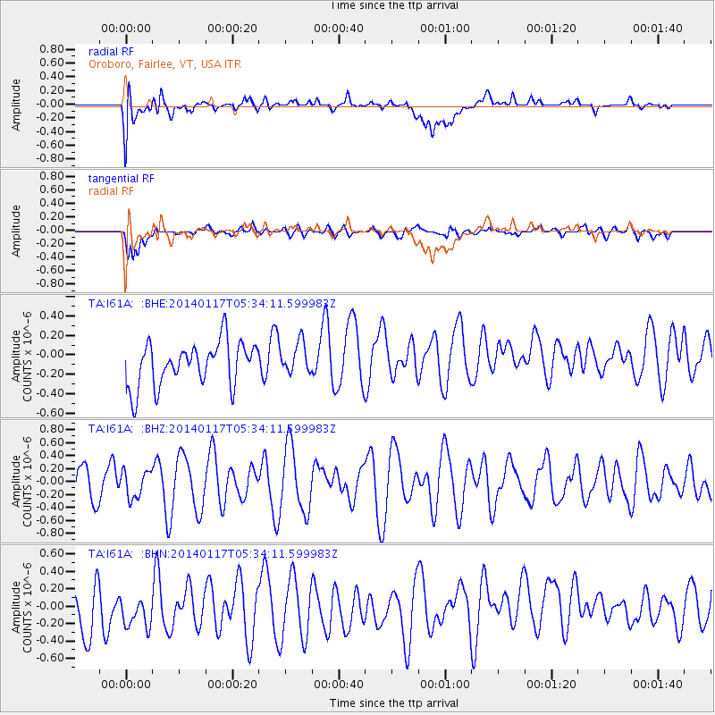
I61A Oroboro, Fairlee, VT, USA - Earthquake Result Viewer
*The percent match for this event was below the threshold and hence no stack was calculated.
| Earthquake location: |
Kuril Islands |
| Earthquake latitude/longitude: |
45.9/150.0 |
| Earthquake time(UTC): |
2014/01/17 (017) 05:22:39 GMT |
| Earthquake Depth: |
200 km |
| Earthquake Magnitude: |
3.7 mb |
| Earthquake Catalog/Contributor: |
ISC/ISC |
|
| Network: |
TA USArray Transportable Network (new EarthScope stations) |
| Station: |
I61A Oroboro, Fairlee, VT, USA |
| Lat/Lon: |
43.93 N/72.21 W |
| Elevation: |
287 m |
|
| Distance: |
83.0 deg |
| Az: |
29.297 deg |
| Baz: |
331.772 deg |
| Ray Param: |
$rayparam |
*The percent match for this event was below the threshold and hence was not used in the summary stack. |
|
| Radial Match: |
40.09328 % |
| Radial Bump: |
400 |
| Transverse Match: |
47.874367 % |
| Transverse Bump: |
400 |
| SOD ConfigId: |
3390531 |
| Insert Time: |
2019-04-10 00:41:29.674 +0000 |
| GWidth: |
2.5 |
| Max Bumps: |
400 |
| Tol: |
0.001 |
|
Signal To Noise
| Channel | StoN | STA | LTA |
| TA:I61A: :BHZ:20140117T05:34:11.599983Z | 0.69192576 | 2.1180793E-7 | 3.0611366E-7 |
| TA:I61A: :BHN:20140117T05:34:11.599983Z | 0.86913514 | 3.3308672E-7 | 3.8323927E-7 |
| TA:I61A: :BHE:20140117T05:34:11.599983Z | 0.72096616 | 1.6140196E-7 | 2.2386897E-7 |
| Arrivals |
| Ps | |
| PpPs | |
| PsPs/PpSs | |


