You are here: Home > Network List > IW - Intermountain West Stations List
> Station DLMT Dillon, Montana, USA > Earthquake Result Viewer
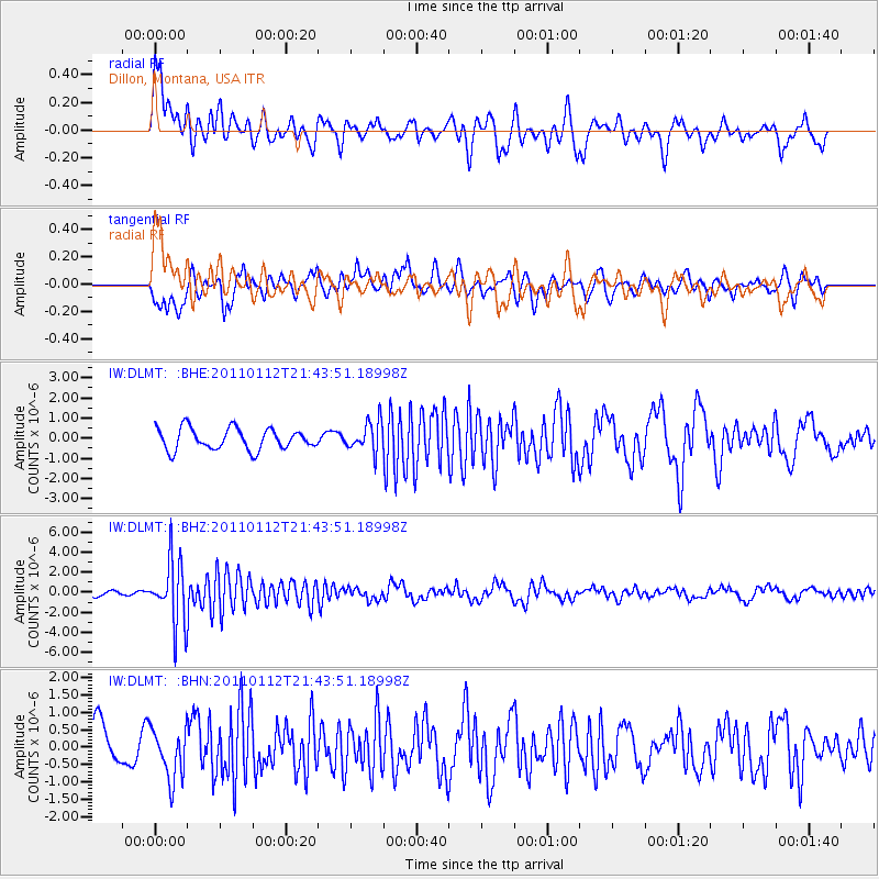
DLMT Dillon, Montana, USA - Earthquake Result Viewer
*The percent match for this event was below the threshold and hence no stack was calculated.
| Earthquake location: |
Bonin Islands, Japan Region |
| Earthquake latitude/longitude: |
27.0/139.9 |
| Earthquake time(UTC): |
2011/01/12 (012) 21:32:55 GMT |
| Earthquake Depth: |
528 km |
| Earthquake Magnitude: |
6.2 MB, 6.5 MW, 6.5 MW |
| Earthquake Catalog/Contributor: |
WHDF/NEIC |
|
| Network: |
IW Intermountain West |
| Station: |
DLMT Dillon, Montana, USA |
| Lat/Lon: |
45.36 N/112.60 W |
| Elevation: |
1569 m |
|
| Distance: |
82.5 deg |
| Az: |
42.691 deg |
| Baz: |
300.876 deg |
| Ray Param: |
$rayparam |
*The percent match for this event was below the threshold and hence was not used in the summary stack. |
|
| Radial Match: |
63.875282 % |
| Radial Bump: |
400 |
| Transverse Match: |
46.262444 % |
| Transverse Bump: |
400 |
| SOD ConfigId: |
346946 |
| Insert Time: |
2011-07-09 09:01:55.115 +0000 |
| GWidth: |
2.5 |
| Max Bumps: |
400 |
| Tol: |
0.001 |
|
Signal To Noise
| Channel | StoN | STA | LTA |
| IW:DLMT: :BHZ:20110112T21:43:51.18998Z | 10.090401 | 3.168933E-6 | 3.1405423E-7 |
| IW:DLMT: :BHN:20110112T21:43:51.18998Z | 1.4049953 | 7.219989E-7 | 5.1387997E-7 |
| IW:DLMT: :BHE:20110112T21:43:51.18998Z | 1.4038261 | 7.4114814E-7 | 5.2794866E-7 |
| Arrivals |
| Ps | |
| PpPs | |
| PsPs/PpSs | |


