You are here: Home > Network List > TA - USArray Transportable Network (new EarthScope stations) Stations List
> Station M53A WI Miller and Sons, Farmdale, OH, USA > Earthquake Result Viewer
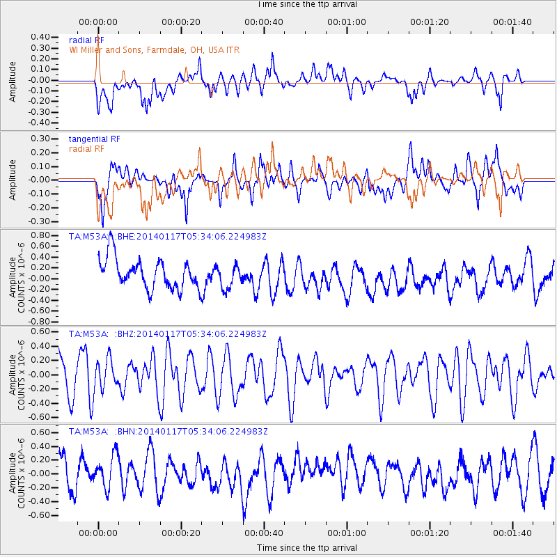
M53A WI Miller and Sons, Farmdale, OH, USA - Earthquake Result Viewer
*The percent match for this event was below the threshold and hence no stack was calculated.
| Earthquake location: |
Kuril Islands |
| Earthquake latitude/longitude: |
45.9/150.0 |
| Earthquake time(UTC): |
2014/01/17 (017) 05:22:39 GMT |
| Earthquake Depth: |
200 km |
| Earthquake Magnitude: |
3.7 mb |
| Earthquake Catalog/Contributor: |
ISC/ISC |
|
| Network: |
TA USArray Transportable Network (new EarthScope stations) |
| Station: |
M53A WI Miller and Sons, Farmdale, OH, USA |
| Lat/Lon: |
41.44 N/80.68 W |
| Elevation: |
334 m |
|
| Distance: |
82.0 deg |
| Az: |
35.991 deg |
| Baz: |
326.92 deg |
| Ray Param: |
$rayparam |
*The percent match for this event was below the threshold and hence was not used in the summary stack. |
|
| Radial Match: |
46.926556 % |
| Radial Bump: |
400 |
| Transverse Match: |
53.512615 % |
| Transverse Bump: |
400 |
| SOD ConfigId: |
3390531 |
| Insert Time: |
2019-04-10 00:41:43.366 +0000 |
| GWidth: |
2.5 |
| Max Bumps: |
400 |
| Tol: |
0.001 |
|
Signal To Noise
| Channel | StoN | STA | LTA |
| TA:M53A: :BHZ:20140117T05:34:06.224983Z | 0.72694623 | 2.0221528E-7 | 2.781709E-7 |
| TA:M53A: :BHN:20140117T05:34:06.224983Z | 1.1878785 | 2.7706812E-7 | 2.3324617E-7 |
| TA:M53A: :BHE:20140117T05:34:06.224983Z | 0.8022129 | 2.2231497E-7 | 2.7712713E-7 |
| Arrivals |
| Ps | |
| PpPs | |
| PsPs/PpSs | |


