You are here: Home > Network List > TA - USArray Transportable Network (new EarthScope stations) Stations List
> Station O03E Paynes Creek, CA, USA > Earthquake Result Viewer
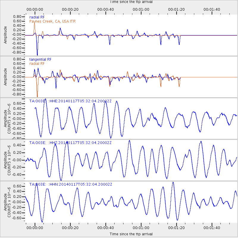
O03E Paynes Creek, CA, USA - Earthquake Result Viewer
*The percent match for this event was below the threshold and hence no stack was calculated.
| Earthquake location: |
Kuril Islands |
| Earthquake latitude/longitude: |
45.9/150.0 |
| Earthquake time(UTC): |
2014/01/17 (017) 05:22:39 GMT |
| Earthquake Depth: |
200 km |
| Earthquake Magnitude: |
3.7 mb |
| Earthquake Catalog/Contributor: |
ISC/ISC |
|
| Network: |
TA USArray Transportable Network (new EarthScope stations) |
| Station: |
O03E Paynes Creek, CA, USA |
| Lat/Lon: |
40.29 N/121.80 W |
| Elevation: |
967 m |
|
| Distance: |
61.4 deg |
| Az: |
60.513 deg |
| Baz: |
307.37 deg |
| Ray Param: |
$rayparam |
*The percent match for this event was below the threshold and hence was not used in the summary stack. |
|
| Radial Match: |
61.21411 % |
| Radial Bump: |
187 |
| Transverse Match: |
71.55608 % |
| Transverse Bump: |
400 |
| SOD ConfigId: |
3390531 |
| Insert Time: |
2019-04-10 00:41:50.250 +0000 |
| GWidth: |
2.5 |
| Max Bumps: |
400 |
| Tol: |
0.001 |
|
Signal To Noise
| Channel | StoN | STA | LTA |
| TA:O03E: :HHZ:20140117T05:32:04.20002Z | 1.055946 | 1.3011469E-7 | 1.2322096E-7 |
| TA:O03E: :HHN:20140117T05:32:04.20002Z | 2.0787275 | 5.015977E-7 | 2.4130037E-7 |
| TA:O03E: :HHE:20140117T05:32:04.20002Z | 0.8276628 | 3.348886E-7 | 4.0461958E-7 |
| Arrivals |
| Ps | |
| PpPs | |
| PsPs/PpSs | |


