You are here: Home > Network List > TA - USArray Transportable Network (new EarthScope stations) Stations List
> Station F27A Lemmon, SD, USA > Earthquake Result Viewer
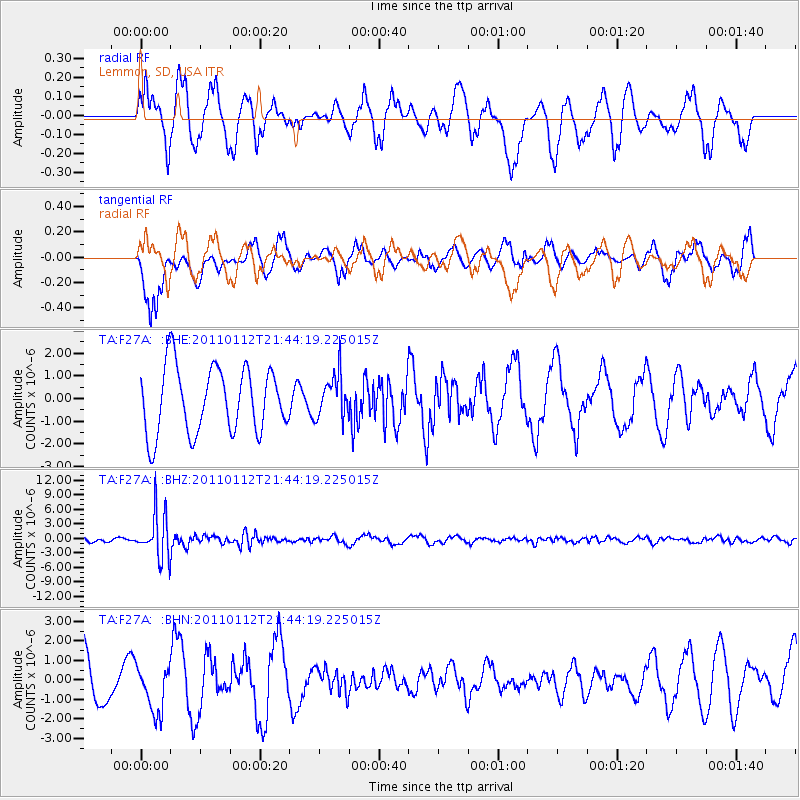
F27A Lemmon, SD, USA - Earthquake Result Viewer
*The percent match for this event was below the threshold and hence no stack was calculated.
| Earthquake location: |
Bonin Islands, Japan Region |
| Earthquake latitude/longitude: |
27.0/139.9 |
| Earthquake time(UTC): |
2011/01/12 (012) 21:32:55 GMT |
| Earthquake Depth: |
528 km |
| Earthquake Magnitude: |
6.2 MB, 6.5 MW, 6.5 MW |
| Earthquake Catalog/Contributor: |
WHDF/NEIC |
|
| Network: |
TA USArray Transportable Network (new EarthScope stations) |
| Station: |
F27A Lemmon, SD, USA |
| Lat/Lon: |
45.87 N/102.02 W |
| Elevation: |
757 m |
|
| Distance: |
88.3 deg |
| Az: |
38.061 deg |
| Baz: |
308.05 deg |
| Ray Param: |
$rayparam |
*The percent match for this event was below the threshold and hence was not used in the summary stack. |
|
| Radial Match: |
34.989944 % |
| Radial Bump: |
309 |
| Transverse Match: |
49.020515 % |
| Transverse Bump: |
400 |
| SOD ConfigId: |
346946 |
| Insert Time: |
2011-07-09 09:22:25.693 +0000 |
| GWidth: |
2.5 |
| Max Bumps: |
400 |
| Tol: |
0.001 |
|
Signal To Noise
| Channel | StoN | STA | LTA |
| TA:F27A: :BHZ:20110112T21:44:19.225015Z | 8.002415 | 4.614885E-6 | 5.7668655E-7 |
| TA:F27A: :BHN:20110112T21:44:19.225015Z | 0.8929392 | 1.2569526E-6 | 1.4076576E-6 |
| TA:F27A: :BHE:20110112T21:44:19.225015Z | 0.65810055 | 9.5348065E-7 | 1.4488373E-6 |
| Arrivals |
| Ps | |
| PpPs | |
| PsPs/PpSs | |


