You are here: Home > Network List > TA - USArray Transportable Network (new EarthScope stations) Stations List
> Station G03D McMinnville, OR, USA > Earthquake Result Viewer
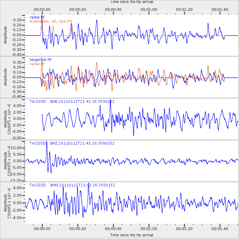
G03D McMinnville, OR, USA - Earthquake Result Viewer
*The percent match for this event was below the threshold and hence no stack was calculated.
| Earthquake location: |
Bonin Islands, Japan Region |
| Earthquake latitude/longitude: |
27.0/139.9 |
| Earthquake time(UTC): |
2011/01/12 (012) 21:32:55 GMT |
| Earthquake Depth: |
528 km |
| Earthquake Magnitude: |
6.2 MB, 6.5 MW, 6.5 MW |
| Earthquake Catalog/Contributor: |
WHDF/NEIC |
|
| Network: |
TA USArray Transportable Network (new EarthScope stations) |
| Station: |
G03D McMinnville, OR, USA |
| Lat/Lon: |
45.21 N/123.26 W |
| Elevation: |
222 m |
|
| Distance: |
75.9 deg |
| Az: |
46.355 deg |
| Baz: |
293.998 deg |
| Ray Param: |
$rayparam |
*The percent match for this event was below the threshold and hence was not used in the summary stack. |
|
| Radial Match: |
61.03139 % |
| Radial Bump: |
400 |
| Transverse Match: |
57.210495 % |
| Transverse Bump: |
400 |
| SOD ConfigId: |
346946 |
| Insert Time: |
2011-07-09 09:35:18.305 +0000 |
| GWidth: |
2.5 |
| Max Bumps: |
400 |
| Tol: |
0.001 |
|
Signal To Noise
| Channel | StoN | STA | LTA |
| TA:G03D: :BHZ:20110112T21:43:16.350015Z | 5.810867 | 5.0810854E-6 | 8.7441094E-7 |
| TA:G03D: :BHN:20110112T21:43:16.350015Z | 1.0098811 | 1.0232413E-6 | 1.0132295E-6 |
| TA:G03D: :BHE:20110112T21:43:16.350015Z | 1.0430323 | 1.6292406E-6 | 1.5620232E-6 |
| Arrivals |
| Ps | |
| PpPs | |
| PsPs/PpSs | |


