You are here: Home > Network List > TA - USArray Transportable Network (new EarthScope stations) Stations List
> Station N34A Lincoln, NE, USA > Earthquake Result Viewer
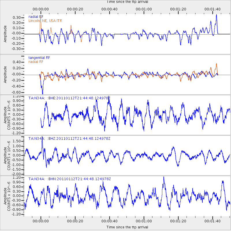
N34A Lincoln, NE, USA - Earthquake Result Viewer
*The percent match for this event was below the threshold and hence no stack was calculated.
| Earthquake location: |
Bonin Islands, Japan Region |
| Earthquake latitude/longitude: |
27.0/139.9 |
| Earthquake time(UTC): |
2011/01/12 (012) 21:32:55 GMT |
| Earthquake Depth: |
528 km |
| Earthquake Magnitude: |
6.2 MB, 6.5 MW, 6.5 MW |
| Earthquake Catalog/Contributor: |
WHDF/NEIC |
|
| Network: |
TA USArray Transportable Network (new EarthScope stations) |
| Station: |
N34A Lincoln, NE, USA |
| Lat/Lon: |
40.84 N/96.50 W |
| Elevation: |
401 m |
|
| Distance: |
94.6 deg |
| Az: |
39.333 deg |
| Baz: |
311.798 deg |
| Ray Param: |
$rayparam |
*The percent match for this event was below the threshold and hence was not used in the summary stack. |
|
| Radial Match: |
47.23204 % |
| Radial Bump: |
400 |
| Transverse Match: |
75.27208 % |
| Transverse Bump: |
400 |
| SOD ConfigId: |
346946 |
| Insert Time: |
2011-07-09 09:36:38.879 +0000 |
| GWidth: |
2.5 |
| Max Bumps: |
400 |
| Tol: |
0.001 |
|
Signal To Noise
| Channel | StoN | STA | LTA |
| TA:N34A: :BHZ:20110112T21:44:48.124978Z | 1.9547553 | 7.432953E-7 | 3.802498E-7 |
| TA:N34A: :BHN:20110112T21:44:48.124978Z | 0.8915942 | 3.8763585E-7 | 4.3476714E-7 |
| TA:N34A: :BHE:20110112T21:44:48.124978Z | 1.3735721 | 4.8029113E-7 | 3.4966575E-7 |
| Arrivals |
| Ps | |
| PpPs | |
| PsPs/PpSs | |


