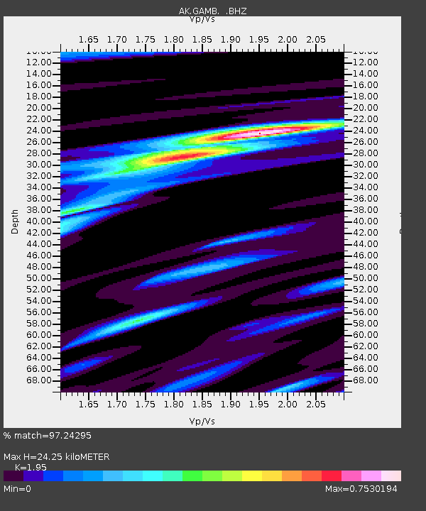
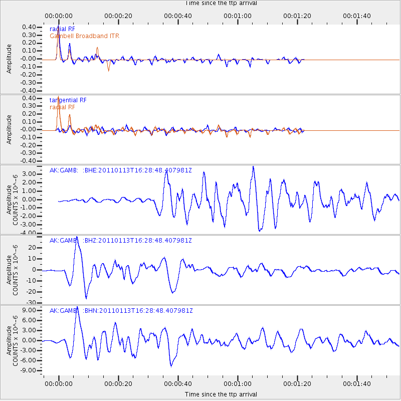
GAMB Gambell Broadband - Earthquake Result Viewer

Earthquake location: Loyalty Islands
Earthquake latitude/longitude: -20.6/168.5
Earthquake time(UTC): 2011/01/13 (013) 16:16:41 GMT
Earthquake Depth: 9.0 km
Earthquake Magnitude: 6.6 MB, 7.1 MS, 7.0 MW, 6.9 MW
Earthquake Catalog/Contributor: WHDF/NEIC
Network: AK Alaska Regional Network
Station: GAMB Gambell Broadband
Lat/Lon: 63.78 N/171.70 W
Elevation: 10 m
Distance: 85.5 deg
Az: 8.694 deg
Baz: 198.583 deg
Ray Param: 0.044689607
Estimated Moho Depth: 24.25 km
Estimated Crust Vp/Vs: 1.95
Assumed Crust Vp: 6.24 km/s
Estimated Crust Vs: 3.2 km/s
Estimated Crust Poisson's Ratio: 0.32
Radial Match: 97.24295 %
Radial Bump: 312
Transverse Match: 88.44263 %
Transverse Bump: 400
SOD ConfigId: 346946
Insert Time: 2011-07-09 10:12:44.630 +0000
GWidth: 2.5
Max Bumps: 400
Tol: 0.001

Signal To Noise

ChannelStoNSTALTA
AK:GAMB: :BHZ:20110113T16:28:48.407981Z38.0454146.321609E-61.6615955E-7
AK:GAMB: :BHN:20110113T16:28:48.407981Z7.52267842.2650618E-63.0109777E-7
AK:GAMB: :BHE:20110113T16:28:48.407981Z5.6406248.61728E-71.5277175E-7
Arrivals
Ps3.8 SECOND
PpPs11 SECOND
PsPs/PpSs15 SECOND