You are here: Home > Network List > AK - Alaska Regional Network Stations List
> Station CHI Chirikof Island > Earthquake Result Viewer
CHI Chirikof Island - Earthquake Result Viewer
| Earthquake location: |
Loyalty Islands |
| Earthquake latitude/longitude: |
-20.6/168.5 |
| Earthquake time(UTC): |
2011/01/13 (013) 16:16:41 GMT |
| Earthquake Depth: |
9.0 km |
| Earthquake Magnitude: |
6.6 MB, 7.1 MS, 7.0 MW, 6.9 MW |
| Earthquake Catalog/Contributor: |
WHDF/NEIC |
|
| Network: |
AK Alaska Regional Network |
| Station: |
CHI Chirikof Island |
| Lat/Lon: |
55.82 N/155.62 W |
| Elevation: |
234 m |
|
| Distance: |
82.0 deg |
| Az: |
19.526 deg |
| Baz: |
213.692 deg |
| Ray Param: |
0.04718687 |
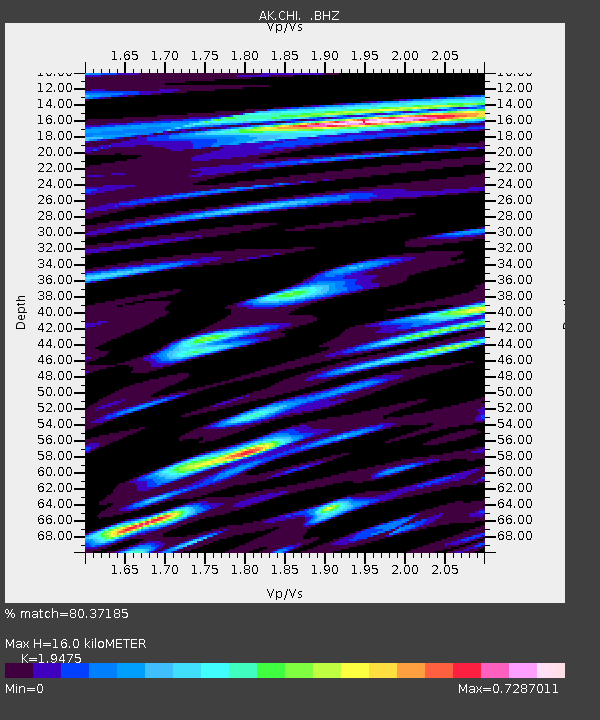
| Estimated Moho Depth: |
16.0 km |
| Estimated Crust Vp/Vs: |
1.95 |
| Assumed Crust Vp: |
3.999 km/s |
| Estimated Crust Vs: |
2.053 km/s |
| Estimated Crust Poisson's Ratio: |
0.32 |
|
| Radial Match: |
80.37185 % |
| Radial Bump: |
400 |
| Transverse Match: |
79.84704 % |
| Transverse Bump: |
400 |
| SOD ConfigId: |
346946 |
| Insert Time: |
2011-07-09 10:13:28.828 +0000 |
| GWidth: |
2.5 |
| Max Bumps: |
400 |
| Tol: |
0.001 |
|

Signal To Noise
| Channel | StoN | STA | LTA |
| AK:CHI: :BHZ:20110113T16:28:30.388022Z | 7.538372 | 8.24704E-6 | 1.0940081E-6 |
| AK:CHI: :BHN:20110113T16:28:30.388022Z | 0.90320957 | 1.6880083E-6 | 1.8688999E-6 |
| AK:CHI: :BHE:20110113T16:28:30.388022Z | 1.2546846 | 1.7673514E-6 | 1.4086022E-6 |
| Arrivals |
| Ps | 3.8 SECOND |
| PpPs | 12 SECOND |
| PsPs/PpSs | 16 SECOND |


