You are here: Home > Network List > AT - Alaska Tsunami Warning Seismic System Stations List
> Station SMY Shemya, Alaska > Earthquake Result Viewer
SMY Shemya, Alaska - Earthquake Result Viewer
| Earthquake location: |
Loyalty Islands |
| Earthquake latitude/longitude: |
-20.6/168.5 |
| Earthquake time(UTC): |
2011/01/13 (013) 16:16:41 GMT |
| Earthquake Depth: |
9.0 km |
| Earthquake Magnitude: |
6.6 MB, 7.1 MS, 7.0 MW, 6.9 MW |
| Earthquake Catalog/Contributor: |
WHDF/NEIC |
|
| Network: |
AT Alaska Tsunami Warning Seismic System |
| Station: |
SMY Shemya, Alaska |
| Lat/Lon: |
52.73 N/174.10 E |
| Elevation: |
58 m |
|
| Distance: |
73.2 deg |
| Az: |
3.574 deg |
| Baz: |
185.51 deg |
| Ray Param: |
0.05315521 |
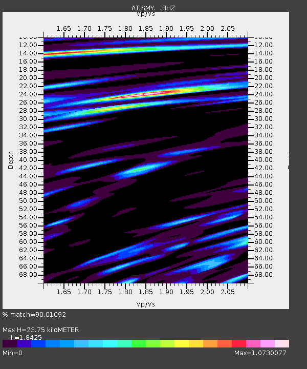
| Estimated Moho Depth: |
23.75 km |
| Estimated Crust Vp/Vs: |
1.84 |
| Assumed Crust Vp: |
3.999 km/s |
| Estimated Crust Vs: |
2.17 km/s |
| Estimated Crust Poisson's Ratio: |
0.29 |
|
| Radial Match: |
90.01092 % |
| Radial Bump: |
400 |
| Transverse Match: |
84.213745 % |
| Transverse Bump: |
400 |
| SOD ConfigId: |
346946 |
| Insert Time: |
2011-07-09 10:15:48.319 +0000 |
| GWidth: |
2.5 |
| Max Bumps: |
400 |
| Tol: |
0.001 |
|

Signal To Noise
| Channel | StoN | STA | LTA |
| AT:SMY: :BHZ:20110113T16:27:41.449973Z | 7.191661 | 9.002333E-6 | 1.2517738E-6 |
| AT:SMY: :BHN:20110113T16:27:41.449973Z | 1.5156983 | 2.3160133E-6 | 1.5280173E-6 |
| AT:SMY: :BHE:20110113T16:27:41.449973Z | 0.76994854 | 1.7325707E-6 | 2.2502422E-6 |
| Arrivals |
| Ps | 5.1 SECOND |
| PpPs | 17 SECOND |
| PsPs/PpSs | 22 SECOND |


