You are here: Home > Network List > TA - USArray Transportable Network (new EarthScope stations) Stations List
> Station G59A Clarenceville, QC, USA > Earthquake Result Viewer
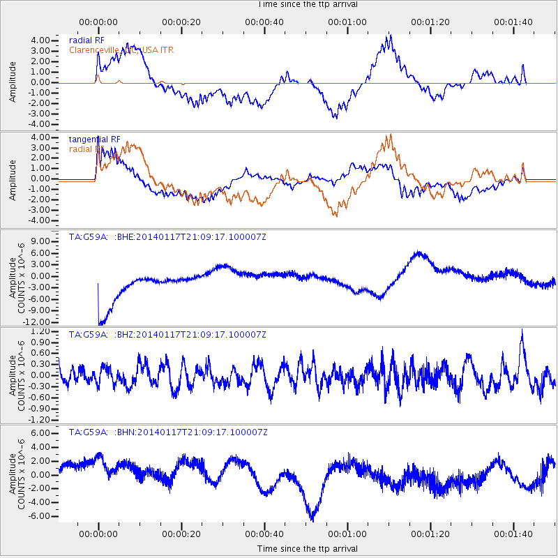
G59A Clarenceville, QC, USA - Earthquake Result Viewer
*The percent match for this event was below the threshold and hence no stack was calculated.
| Earthquake location: |
Costa Rica |
| Earthquake latitude/longitude: |
9.6/-84.8 |
| Earthquake time(UTC): |
2014/01/17 (017) 21:02:42 GMT |
| Earthquake Depth: |
27 km |
| Earthquake Magnitude: |
5.3 MW |
| Earthquake Catalog/Contributor: |
ISC/ISC |
|
| Network: |
TA USArray Transportable Network (new EarthScope stations) |
| Station: |
G59A Clarenceville, QC, USA |
| Lat/Lon: |
45.08 N/73.18 W |
| Elevation: |
36 m |
|
| Distance: |
36.7 deg |
| Az: |
13.811 deg |
| Baz: |
199.407 deg |
| Ray Param: |
$rayparam |
*The percent match for this event was below the threshold and hence was not used in the summary stack. |
|
| Radial Match: |
36.736595 % |
| Radial Bump: |
400 |
| Transverse Match: |
37.63444 % |
| Transverse Bump: |
400 |
| SOD ConfigId: |
3390531 |
| Insert Time: |
2019-04-10 00:48:15.258 +0000 |
| GWidth: |
2.5 |
| Max Bumps: |
400 |
| Tol: |
0.001 |
|
Signal To Noise
| Channel | StoN | STA | LTA |
| TA:G59A: :BHZ:20140117T21:09:17.100007Z | 0.7995442 | 2.2108043E-7 | 2.7650808E-7 |
| TA:G59A: :BHN:20140117T21:09:17.100007Z | 1.3543572 | 5.1841535E-6 | 3.8277594E-6 |
| TA:G59A: :BHE:20140117T21:09:17.100007Z | 1.3651289 | 4.833406E-6 | 3.5406224E-6 |
| Arrivals |
| Ps | |
| PpPs | |
| PsPs/PpSs | |


