You are here: Home > Network List > BK - Berkeley Digital Seismograph Network Stations List
> Station SAO San Andreas Geophysical Obs., Hollister, CA, USA > Earthquake Result Viewer
SAO San Andreas Geophysical Obs., Hollister, CA, USA - Earthquake Result Viewer
| Earthquake location: |
Loyalty Islands |
| Earthquake latitude/longitude: |
-20.6/168.5 |
| Earthquake time(UTC): |
2011/01/13 (013) 16:16:41 GMT |
| Earthquake Depth: |
9.0 km |
| Earthquake Magnitude: |
6.6 MB, 7.1 MS, 7.0 MW, 6.9 MW |
| Earthquake Catalog/Contributor: |
WHDF/NEIC |
|
| Network: |
BK Berkeley Digital Seismograph Network |
| Station: |
SAO San Andreas Geophysical Obs., Hollister, CA, USA |
| Lat/Lon: |
36.76 N/121.45 W |
| Elevation: |
317 m |
|
| Distance: |
87.3 deg |
| Az: |
49.099 deg |
| Baz: |
241.839 deg |
| Ray Param: |
0.043440975 |
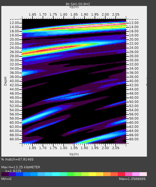
| Estimated Moho Depth: |
13.25 km |
| Estimated Crust Vp/Vs: |
1.92 |
| Assumed Crust Vp: |
6.391 km/s |
| Estimated Crust Vs: |
3.324 km/s |
| Estimated Crust Poisson's Ratio: |
0.31 |
|
| Radial Match: |
87.91465 % |
| Radial Bump: |
400 |
| Transverse Match: |
90.01899 % |
| Transverse Bump: |
400 |
| SOD ConfigId: |
346946 |
| Insert Time: |
2011-07-09 10:24:34.400 +0000 |
| GWidth: |
2.5 |
| Max Bumps: |
400 |
| Tol: |
0.001 |
|
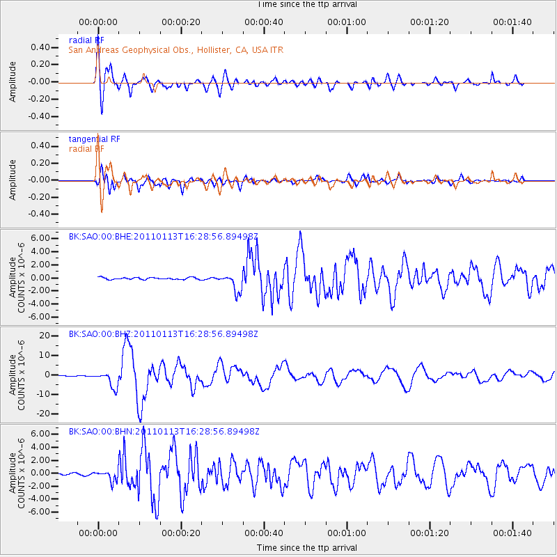
Signal To Noise
| Channel | StoN | STA | LTA |
| BK:SAO:00:BHZ:20110113T16:28:56.89498Z | 20.388155 | 4.213232E-6 | 2.0665097E-7 |
| BK:SAO:00:BHN:20110113T16:28:56.89498Z | 4.1711683 | 8.1305734E-7 | 1.9492316E-7 |
| BK:SAO:00:BHE:20110113T16:28:56.89498Z | 9.670856 | 1.4530207E-6 | 1.5024736E-7 |
| Arrivals |
| Ps | 2.0 SECOND |
| PpPs | 5.9 SECOND |
| PsPs/PpSs | 7.9 SECOND |


