You are here: Home > Network List > CI - Caltech Regional Seismic Network Stations List
> Station RPV Rancho Palos Verdes, California, USA > Earthquake Result Viewer
RPV Rancho Palos Verdes, California, USA - Earthquake Result Viewer
| Earthquake location: |
Loyalty Islands |
| Earthquake latitude/longitude: |
-20.6/168.5 |
| Earthquake time(UTC): |
2011/01/13 (013) 16:16:41 GMT |
| Earthquake Depth: |
9.0 km |
| Earthquake Magnitude: |
6.6 MB, 7.1 MS, 7.0 MW, 6.9 MW |
| Earthquake Catalog/Contributor: |
WHDF/NEIC |
|
| Network: |
CI Caltech Regional Seismic Network |
| Station: |
RPV Rancho Palos Verdes, California, USA |
| Lat/Lon: |
33.74 N/118.40 W |
| Elevation: |
64 m |
|
| Distance: |
88.1 deg |
| Az: |
52.921 deg |
| Baz: |
243.743 deg |
| Ray Param: |
0.042829715 |
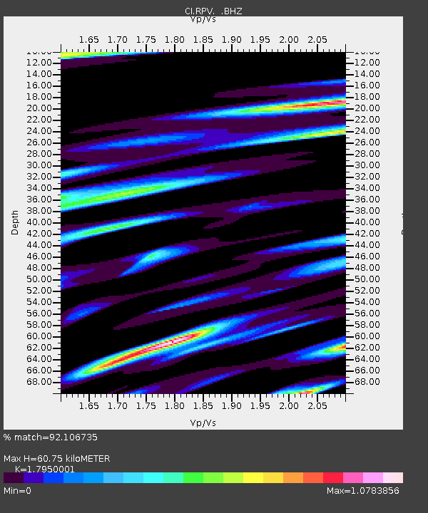
| Estimated Moho Depth: |
60.75 km |
| Estimated Crust Vp/Vs: |
1.80 |
| Assumed Crust Vp: |
6.048 km/s |
| Estimated Crust Vs: |
3.369 km/s |
| Estimated Crust Poisson's Ratio: |
0.27 |
|
| Radial Match: |
92.106735 % |
| Radial Bump: |
400 |
| Transverse Match: |
85.02319 % |
| Transverse Bump: |
400 |
| SOD ConfigId: |
346946 |
| Insert Time: |
2011-07-09 10:31:34.487 +0000 |
| GWidth: |
2.5 |
| Max Bumps: |
400 |
| Tol: |
0.001 |
|

Signal To Noise
| Channel | StoN | STA | LTA |
| CI:RPV: :BHZ:20110113T16:29:00.89498Z | 14.496401 | 4.7703725E-6 | 3.290729E-7 |
| CI:RPV: :BHN:20110113T16:29:00.89498Z | 2.1788464 | 9.661954E-7 | 4.434436E-7 |
| CI:RPV: :BHE:20110113T16:29:00.89498Z | 3.3463438 | 1.4173357E-6 | 4.2354756E-7 |
| Arrivals |
| Ps | 8.1 SECOND |
| PpPs | 28 SECOND |
| PsPs/PpSs | 36 SECOND |


