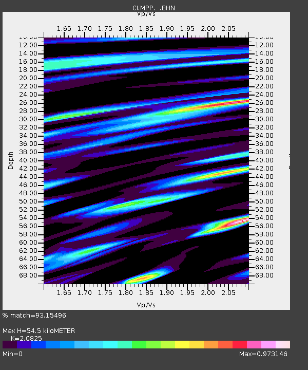
MPP McPhearson Peak - Earthquake Result Viewer
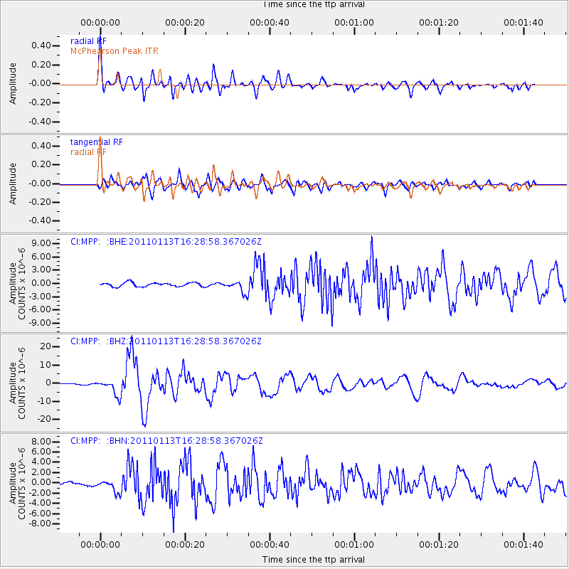
Earthquake location: Loyalty Islands
Earthquake latitude/longitude: -20.6/168.5
Earthquake time(UTC): 2011/01/13 (013) 16:16:41 GMT
Earthquake Depth: 9.0 km
Earthquake Magnitude: 6.6 MB, 7.1 MS, 7.0 MW, 6.9 MW
Earthquake Catalog/Contributor: WHDF/NEIC
Network: CI Caltech Regional Seismic Network
Station: MPP McPhearson Peak
Lat/Lon: 34.89 N/119.81 W
Elevation: 1739 m
Distance: 87.6 deg
Az: 51.375 deg
Baz: 242.894 deg
Ray Param: 0.043223258
Estimated Moho Depth: 54.5 km
Estimated Crust Vp/Vs: 2.08
Assumed Crust Vp: 6.1 km/s
Estimated Crust Vs: 2.929 km/s
Estimated Crust Poisson's Ratio: 0.35
Radial Match: 93.15496 %
Radial Bump: 400
Transverse Match: 85.2562 %
Transverse Bump: 400
SOD ConfigId: 346946
Insert Time: 2011-07-09 10:41:45.640 +0000
GWidth: 2.5
Max Bumps: 400
Tol: 0.001

Signal To Noise

ChannelStoNSTALTA
CI:MPP: :BHZ:20110113T16:28:58.367026Z20.7027764.5404763E-62.1931727E-7
CI:MPP: :BHN:20110113T16:28:58.367026Z4.8757091.2137083E-62.489296E-7
CI:MPP: :BHE:20110113T16:28:58.367026Z3.14545441.3835376E-64.39853E-7
Arrivals
Ps9.8 SECOND
PpPs27 SECOND
PsPs/PpSs37 SECOND