You are here: Home > Network List > TA - USArray Transportable Network (new EarthScope stations) Stations List
> Station 109C Camp Elliot, Mirimar, CA, USA > Earthquake Result Viewer
109C Camp Elliot, Mirimar, CA, USA - Earthquake Result Viewer
| Earthquake location: |
Loyalty Islands |
| Earthquake latitude/longitude: |
-20.6/168.5 |
| Earthquake time(UTC): |
2011/01/13 (013) 16:16:41 GMT |
| Earthquake Depth: |
9.0 km |
| Earthquake Magnitude: |
6.6 MB, 7.1 MS, 7.0 MW, 6.9 MW |
| Earthquake Catalog/Contributor: |
WHDF/NEIC |
|
| Network: |
TA USArray Transportable Network (new EarthScope stations) |
| Station: |
109C Camp Elliot, Mirimar, CA, USA |
| Lat/Lon: |
32.89 N/117.11 W |
| Elevation: |
150 m |
|
| Distance: |
88.7 deg |
| Az: |
54.163 deg |
| Baz: |
244.487 deg |
| Ray Param: |
0.042378 |
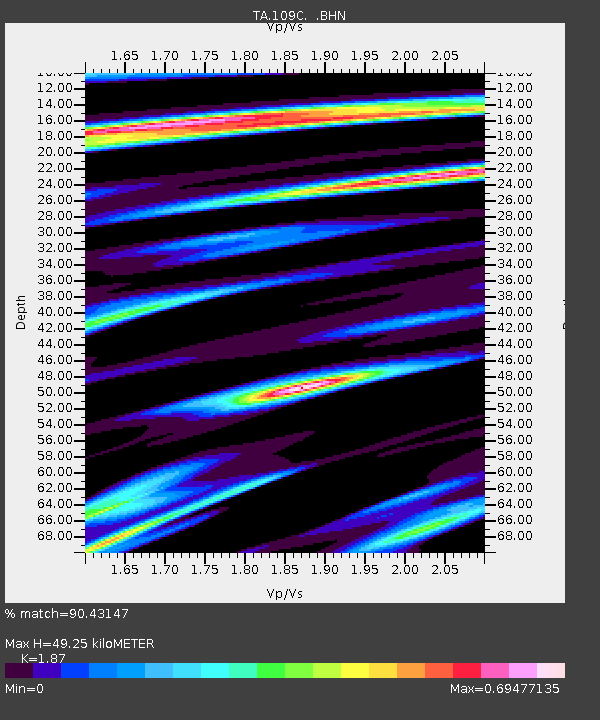
| Estimated Moho Depth: |
49.25 km |
| Estimated Crust Vp/Vs: |
1.87 |
| Assumed Crust Vp: |
6.264 km/s |
| Estimated Crust Vs: |
3.35 km/s |
| Estimated Crust Poisson's Ratio: |
0.30 |
|
| Radial Match: |
90.43147 % |
| Radial Bump: |
400 |
| Transverse Match: |
82.93383 % |
| Transverse Bump: |
400 |
| SOD ConfigId: |
346946 |
| Insert Time: |
2011-07-09 11:03:25.127 +0000 |
| GWidth: |
2.5 |
| Max Bumps: |
400 |
| Tol: |
0.001 |
|

Signal To Noise
| Channel | StoN | STA | LTA |
| TA:109C: :BHZ:20110113T16:29:03.745017Z | 11.942727 | 3.32407E-6 | 2.7833426E-7 |
| TA:109C: :BHN:20110113T16:29:03.745017Z | 3.6565552 | 6.59955E-7 | 1.8048544E-7 |
| TA:109C: :BHE:20110113T16:29:03.745017Z | 4.805284 | 1.1269696E-6 | 2.3452715E-7 |
| Arrivals |
| Ps | 7.0 SECOND |
| PpPs | 22 SECOND |
| PsPs/PpSs | 29 SECOND |


