You are here: Home > Network List > TA - USArray Transportable Network (new EarthScope stations) Stations List
> Station I05D Terrebonne, OR, USA > Earthquake Result Viewer
I05D Terrebonne, OR, USA - Earthquake Result Viewer
| Earthquake location: |
Loyalty Islands |
| Earthquake latitude/longitude: |
-20.6/168.5 |
| Earthquake time(UTC): |
2011/01/13 (013) 16:16:41 GMT |
| Earthquake Depth: |
9.0 km |
| Earthquake Magnitude: |
6.6 MB, 7.1 MS, 7.0 MW, 6.9 MW |
| Earthquake Catalog/Contributor: |
WHDF/NEIC |
|
| Network: |
TA USArray Transportable Network (new EarthScope stations) |
| Station: |
I05D Terrebonne, OR, USA |
| Lat/Lon: |
44.34 N/121.34 W |
| Elevation: |
1546 m |
|
| Distance: |
90.9 deg |
| Az: |
42.469 deg |
| Baz: |
241.805 deg |
| Ray Param: |
0.04163879 |
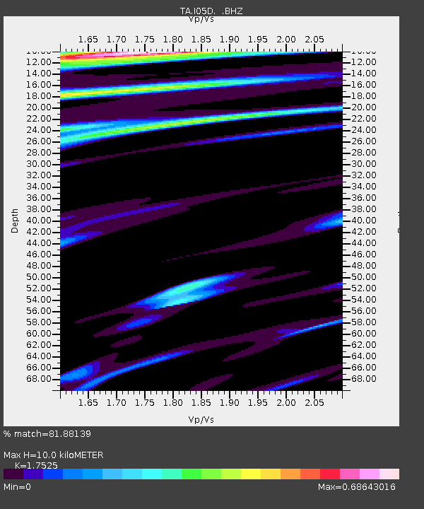
| Estimated Moho Depth: |
10.0 km |
| Estimated Crust Vp/Vs: |
1.75 |
| Assumed Crust Vp: |
6.597 km/s |
| Estimated Crust Vs: |
3.765 km/s |
| Estimated Crust Poisson's Ratio: |
0.26 |
|
| Radial Match: |
81.88139 % |
| Radial Bump: |
400 |
| Transverse Match: |
75.60184 % |
| Transverse Bump: |
400 |
| SOD ConfigId: |
346946 |
| Insert Time: |
2011-07-09 11:12:24.866 +0000 |
| GWidth: |
2.5 |
| Max Bumps: |
400 |
| Tol: |
0.001 |
|

Signal To Noise
| Channel | StoN | STA | LTA |
| TA:I05D: :BHZ:20110113T16:29:14.000022Z | 8.172655 | 4.5100965E-6 | 5.5185205E-7 |
| TA:I05D: :BHN:20110113T16:29:14.000022Z | 1.2833921 | 1.4544933E-6 | 1.1333194E-6 |
| TA:I05D: :BHE:20110113T16:29:14.000022Z | 1.8401281 | 1.2877509E-6 | 6.998159E-7 |
| Arrivals |
| Ps | 1.2 SECOND |
| PpPs | 4.1 SECOND |
| PsPs/PpSs | 5.2 SECOND |


